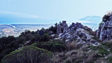
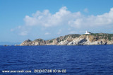
San Lorenzo cape is identified by the round tower that Stands at 184 m. It is dark and rocky.
From the cape, the coast, for a distance of 3 miles to the S, is backed close inland by a chain of hills with flattened conical summits. This stretch of the coast is fringed with shoals and should not be approached within 0.5 mile.
2012/10/12
Update
Joëlle
Le cap S Lorenzo est reconnaissable à la tour ronde qui le domine à 184m. Il est foncé et rocheux.
A partir du cap, la côte, sur 3 MN vers le S, est composée d'une chaîne de collines avec des sommets en forme de cônes aplatis. Cette partie de la côte est bordée de bancs et ne doit pas être approchée à moins de 0,5 MN.
2012/10/12
Update
Joëlle
Capo S Lorenzo è riconoscibile per la torre rotonda che domina a 184m. E 'buio e roccioso.
Dal promontorio, la costa, su 3 MN verso S , è costituita da una serie di colline con punte appiattite a forma di cono. Questa parte della costa è piena di banchi e non deve essere affrontata entro 0,5 MN.
Between Capo Bellavista and Capo Sferracavallo, 13 miles S, the coast alternates in high rocky stretches and low, sandy, and marshy stretches. The coast between Torre di Porto Corallo and Capo Ferrato is low, sandy, and backed by salt water lagoons. It is fringed with shoals and ...
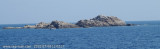
The islet di Quirra (scoglio di Murtas) is located in front of Quirra castle, between Murtas tower and S. Lorenzo cape. It is 12 m high and is surrounded by smaller rocks. It is 12 NM SSE of Murtas tower and 1 NM offshore.From the NNE, this islet appears reddish with a whitish top.A ...
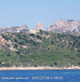
Cala di Murtas, also also known under the name of cove Quirra, bordered by a long sandy beach, lies between the tower and Cape S. Lorenzo. The cove is dominated by the ruins of the castle Quirra which stood on 296 m high hill.
Murtas tower, stands 7 miles S of Torre San Giovanni di Sarrala, fortification of the Kingdom of Sardinia, is located on a hill overlooking the beautiful beach of Murtas. The tower has the characteristic shape of a truncated cone with different openings and dome. It was built between ...
Capo Ferrato, a steep and whitish promontory, 51 m, rises to Monte Ferru, 299m high and fall steeply on the sea. This conical hill stands 1.5 miles inland and is surmounted by a prominent white, tower, 10 m high.


")
 San Lorenzo cape is identified by the round tower that Stands at 184 m. It is dark and rocky.
 Le cap S Lorenzo est reconnaissable à la tour ronde qui le domine à 184m. Il est foncé et rocheux.
 Capo S Lorenzo è riconoscibile per la torre rotonda che domina a 184m. E 'buio e roccioso.