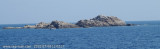
La tour Murtas, au S du cap Palmeri, domine le rivage. Quelques rochers rougeâtres émergent à l'E de la tour
2008-10-31
Update
Torre de Murtas
Torre de Murtas
2010:07:08 11:07:39
2011-07-22
Update
Atoi
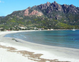
Cala di Murtas, also also known under the name of cove Quirra, bordered by a long sandy beach, lies between the tower and Cape S. Lorenzo. The cove is dominated by the ruins of the castle Quirra which stood on 296 m high hill.
2012/10/12
Update
Joëlle
L'anse di Murtas, connue aussi sous le nom d'anse de Quirra, bordée d'une longue plage de sable, s'étend entre la tour et le cap S. Lorenzo. L'anse est dominée par les ruines remarquables du château de Quirra qui s'élèvent sur la colline haute de 296 m.
2012/10/12
Update
Joëlle
Cala di Murtas, chiamata anche cala di Quirra, delimitata da una lunga spiaggia di sabbia, si trova tra la torre e Capo S. Lorenzo. La baia è dominata dalle rovine del castello Quirra che sorgeva sulla collina alta di 296 m.
2012/10/12
Update
Joëlle
Attention, devant le centre de l'anse, le rocher de Quirra (Chirra), haut de 12 m, entouré de quelques autres rochers, émerge à l'extrémité W d'un banc couvert de 4 m d'eau.
Murtas tower, stands 7 miles S of Torre San Giovanni di Sarrala, fortification of the Kingdom of Sardinia, is located on a hill overlooking the beautiful beach of Murtas. The tower has the characteristic shape of a truncated cone with different openings and dome. It was built between ...
The islet di Quirra (scoglio di Murtas) is located in front of Quirra castle, between Murtas tower and S. Lorenzo cape. It is 12 m high and is surrounded by smaller rocks. It is 12 NM SSE of Murtas tower and 1 NM offshore.From the NNE, this islet appears reddish with a whitish top.A ...
San Lorenzo cape is identified by the round tower that Stands at 184 m. It is dark and rocky.From the cape, the coast, for a distance of 3 miles to the S, is backed close inland by a chain of hills with flattened conical summits. This stretch of the coast is fringed with shoals and ...
Between Capo Bellavista and Capo Sferracavallo, 13 miles S, the coast alternates in high rocky stretches and low, sandy, and marshy stretches. The coast between Torre di Porto Corallo and Capo Ferrato is low, sandy, and backed by salt water lagoons. It is fringed with shoals and ...
Beautiful bay whose white beach named from the wide mouth of the river that flows into it. It is 1 NM S capo Sferracavallo.Ancorage during good weather, sheltered of W winds.


") La tour Murtas, au S du cap Palmeri, domine le rivage. Quelques rochers rougeâtres émergent à l'E de la tour
La tour Murtas, au S du cap Palmeri, domine le rivage. Quelques rochers rougeâtres émergent à l'E de la tour")
 Cala di Murtas, also also known under the name of cove Quirra, bordered by a long sandy beach, lies between the tower and Cape S. Lorenzo. The cove is dominated by the ruins of the castle Quirra which stood on 296 m high hill.
 L'anse di Murtas, connue aussi sous le nom d'anse de Quirra, bordée d'une longue plage de sable, s'étend entre la tour et le cap S. Lorenzo. L'anse est dominée par les ruines remarquables du château de Quirra qui s'élèvent sur la colline haute de 296 m.
 Cala di Murtas, chiamata anche cala di Quirra, delimitata da una lunga spiaggia di sabbia, si trova tra la torre e Capo S. Lorenzo. La baia è dominata dalle rovine del castello Quirra che sorgeva sulla collina alta di 296 m.
") Attention, devant le centre de l'anse, le rocher de Quirra (Chirra), haut de 12 m, entouré de quelques autres rochers, émerge à l'extrémité W d'un banc couvert de 4 m d'eau.
Attention, devant le centre de l'anse, le rocher de Quirra (Chirra), haut de 12 m, entouré de quelques autres rochers, émerge à l'extrémité W d'un banc couvert de 4 m d'eau.") Le château de Quirra
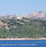
Le château de Quirra