Chia tower was built on a promontory in 1639. The construction was part of the defensive network composed of the coastal towers, set up between the sixteenth and seventeenth centuries by the Crown of Spain against the incursions of the Barbary pirates. The Tower of Chia had two guns.
2012/10/20
Update
Joëlle
La tour Chia fut construite sur un promontoire en 1639. La construction faisait partie du réseau défensif constitué par les tours côtières, mis en place entre le XVIe et XVIIe siècles par la Couronne d'Espagne contre les incursions des pirates barbaresques. La Tour de Chia avait deux canons.
2012/10/20
Update
Joëlle
La torre di Chia fu eretta su un promontorio nel 1639. La costruzione faceva parte della rete difensiva composta dalle torri costiere, allestita fra i secoli XVI e XVII dalla Corona di Spagna contro le incursioni dei corsari barbareschi. La Torre di Chia era dotata di due cannoni.
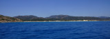
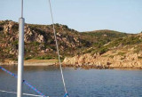
Cala Cipolla is just S of Chia bay and before Spartivento cape. An islet separated from the mainland by a narrow isthmus is an ideal base to anchor, even for the night.
It is well protected from the winds (NW and E) and offers good anchorage by 4/5 m.
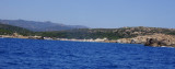
Spartivento cape is at about 5 km SW of Chia. The granite promontory is 66 m above sea level.
Passing the fort you should be wary of two shoals covered with 3.5 m and 11.5 m near the E.
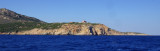
E cape is the beautiful beach of Portu Simoni Gibudda, call cala Cipolla. W are the rocks ...
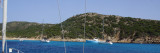
Cala Perda Longa is E Malfatano gulf. It has the same name of the village that overlooks the cove.We can anchor, but you must remain at the entrance of the cove (10 m) because, to the beach, the funds raise quickly.


")
")