Golfo Malfatano (Teulada Sardegna)

Golfo Malfatano (Teulada Sardegna)

To precisely geolocate this site. Update if necessary.

Localisation

Golfo Malfatano (Teulada Sardegna)
LatitudeLongitude
DMS------
DM------
DD------

Characteristics

Coast
Mooring buoy
Mooring
Sand
Restaurant
Beach
Sand

Description

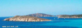
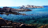
The small Malfatano gulf, appearance desert, ends at W Malfatano Cape.

Tuarredda islet, facing the beach, can be reached on foot from the latter by low tide.

Care must be taken to shallow areas that occupy a good half of the Gulf. Keep the left when entering the Gulf.
If your Draft is greater than 2 m, it is impossible to get into alignment Tuarredda-Spartivento.
At the bottom, but only for those who have a draft of 1,5 m there are buoys for local fishing boats.

Sandbars mixed with mud and weed are constantly in moving, it is necessary to be very careful!
2012/10/21
Update
Joëlle
Le petit golfe Malfatano, d'aspect désertique, se termine à l'W par le cap Malfatano.

L'îlot Tuarredda, face à la plage, peut être rejointe à pied depuis celle-ci  par marrée basse.

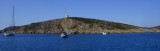
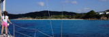
Il faut prendre garde aux zones peu profondes qui occupent une bonne moitié du golfe. Se tenir à gauche en entrant dans le golfe.
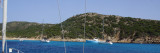
Si votre TE est supérieur à 2 m, il est impossible de se mettre dans l'alignement Tuarredda-Spartivento.
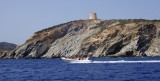
Au fond, mais seulement pour ceux qui ont un TE à 1,5 m au plus, il y a des bouées pour les bateaux de pêche locaux.

Les bancs de sable mélangés avec de la boue et les algues sont constamment en mouvement, il est nécessaire d'être très prudent!

2012/10/21
Update
Joëlle
Il piccolo golfo di Malfatano, di aspetto deserto si termina all'W da il capo Malfatano.

L'isolotto Tuarredda, di fronte alla spiaggia, puo essere raggiunto a piedi da questa da bassa marea.

Attenzione ai bassi fondali che occupano una buona metà del golfo. Occorre tenersi sulla sinistra in entrata nello golfo.
Per chi pesca fino a 2 m, è impossibile spingersi oltre l’allineamento Tuarredda-Spartivento.
In fondo, ma solo per chi pesca fino a 1,5 m, vi sono dei gavitelli usati da pescherecci locali.

I banchi di sabbia mista a fango e alghe si spostano continuamente, per cui è necessario prestare la massima attenzione!

2012/10/21
Update
Joëlle
Ebook

Sardegna South

  • 72 sites
  • 178 photos
  • publication date: 11 Jul 2023
  • .pdf file size: 38 Mb
Share your comments or photos on "Golfo Malfatano (Teulada Sardegna)"

Sites around Golfo Malfatano (Teulada Sardegna)

Flying distances - Direct line

Cala Tuarredda (Malfatano Sardegna)

0.2nm
239°
This cove is sheltered in part by Tuarredda island which is separated from the mainland by an isthmus barely submerged.

There is a shelter wich is between the Malfatano Cape tower and the end  S  Tuarredda Island, by 15 m, or in E of the island on the alignment of ...
21 Oct 12
Joëlle

Cala Malfatano (Malfatano Sardegna)

0.6nm
261°
This is the last anchorage in the Gulf of Malfatano just before the cape.
Beautiful anchorage by 11 m. You cannot go furthr to the north of the bay, due to shallow water.
13 Aug 18
Joëlle

Cala Perda Longa (Malfatano Sardegna)

0.5nm
130°
Cala Perda Longa is E Malfatano gulf. It has the same name of the village that overlooks the cove.We can anchor, but you must remain at the entrance of the cove (10 m) because, to the beach, the funds raise quickly.
21 Oct 12
Joëlle

Capo Malfatano (Teulada Sardegna)

0.8nm
233°
Malfatano cape is a strip of land which is projected into the sea, S of Sardinia.
It closes at the W Gulf Malfatano.

The cape has at its top a round tower whitish.
21 Oct 12
Joëlle