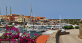
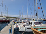
Port Stintino arises from a peninsula that is split into two parts: the N (Mannu port) and the S (Minore port).
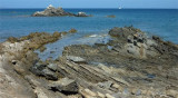
Port Minore: depths are not high. Access is dangerous because is a shoal between the lighthouse and the city.
110 b. (<30 m) Quay depth: 0,40 à 2,50m Tel: Comune di Stintino, tel. 079 523508 Nautica Benenati, tel. 079 523345
The harbor is an haven for yachting with its boats with lateen sails and its outer harbor is well sheltered from winds of offshore. Going right, there are piers without water.
Well sheltered from N and E wind, open to the S. Power as possible.
2012/11/21
Update
Joëlle
2012-11-21
Update
Joëlle
Le port de Stintino surgit d'une péninsule qui est séparée en deux parties: celle du N (porto Mannu) et celle du S (Porte Minore).
Port Minore: les profondeurs ne sont pas élevées. L'accès est dangereux: haut-fond entre le phare et la ville.
110 pl. (<30 m) Profondeur au quai: 0,40 à 2,50m Tel: Comune di Stintino, tel. 079 523508 Nautica Benenati, tel. 079 523345
Le port est un paradis pour la plaisance avec ses barques à voiles latines et son avant-port qui est bien abrité des vents du larges. En entrant à droite il y a des pontons sans eau.
Bien abrité des vents N et E, ouvert au S. Ravitaillement possible.
2012/11/21
Update
Joëlle
2012-11-21
Update
Joëlle
Il porto di Stintino sorge da una penisola che è separato in due parti: quella di N (Porto Mannu) e quella di S (Porto Minore). Porto Minore: i fondali sono bassi. L'accesso è pericoloso: secca tra la meda luminosa e il paese.
110 pb. (<30 m) Profondità in banchina: 0,40 a 2,50 m Tel: Comune di Stintino, tel. 079 523508 Nautica Benenati, tel. 079 523345
Il porto è un paradiso per il yachting con le sue barche con vele latine e il suo porto esterno che è ben riparato dei venti del larghe. Entrando a destra, ci sono pontili senza acqua.
Bene riparato dei venti N e E, aperto al S. Alimentazione possibile.
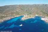
The park begins at Capo Galera to continue toward the gulf of Porto Conte that is protected by two promontories, Punta Giglio and Capo Caccia-Monte Timidone. The marine protected area embraces the stretch of sea to the north-west of Punta Cristallo.Almost all of the park consists ...
Super small fishing village composed of two deep 'Calas'.
South Porto Minore frequented by fishermen. North Porto Mannu, friendly little marina.Mannu Port: can be used by vessels with 2.3 m Max draft. 300 b. incl. 30 visit.(<13 m) T./F. 523381Mail: stintino@guardiacostiera.itThe ...
Coordinates WP 40° 56', 12N 08° 13', 97E DescriptionThe harbour Marina of Stintino is located below the jetty of the port of Stintino, is equipped with floating and fixed docks complete with water and electricity DangersShoal in front beacon light, between the coast ...
Piana Island (23 m high) can ideally be considered as the link between Stintino Peninsula, bordered to the north by Capo Falcone and the island of Asinara. Its name comes from the flatness and surface low and steady. It is close to nearby beaches of Pelosa and Pelosetta, of Stintino. The ...
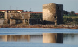
La torre delle Saline, is a part of fortified structures which, since the Middle Ages until the mid-nineteenth century, formed the defensive system of warning and communication of Sardinian coast.
The tower is located on the edge of the sea at the north end of the beach ...


 Bonne tenue
 Bonne tenue
 canal 16, 9


 Port Stintino arises from a peninsula that is split into two parts: the N (Mannu port) and the S (Minore port).
")
 Le port de Stintino surgit d'une péninsule qui est séparée en deux parties: celle du N (porto Mannu) et celle du S (Porte Minore).
")
 Il porto di Stintino sorge da una penisola che è separato in due parti: quella di N (Porto Mannu) e quella di S (Porto Minore).
")