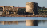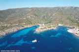


Area Marina Protetta di Capo Caccia - I. Piana (Sardegna)
20nm
185°
20 Nov 12
Joëlle
| Latitude | Longitude | |
| DMS | --- | --- |
| DM | --- | --- |
| DD | --- | --- |

 canal 09


")
")
 Coordinates
")
our phone numbers are 0039 079 523180 and 0039 334 7404583
VHF channel 9
open all year round
 coordonnées
Coordinate
WP 40° 56', 12N 08° 13', 97E
Descrizione
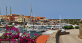
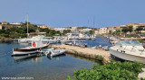
Il porticciolo turistico Marina di Stintino è situato a ridosso del molo di sopraflutto del porto di Stintino ed è dotato di pontili galleggianti e banchina fissa completi di acqua potabile ed ed energia elettrica
Pericoli
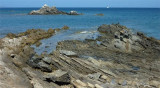
Secca antistante meda luminosa tra la costa e la meda stessa
Orario di accesso
Vedere Regolamento
Accesso
Aspettare all’imboccatura del porto, contattare il servizio porto sul VHF, canale 09. Rispettare la velocità inferiore ai tre nodi e lasciare la precedenza alle imbarcazioni in uscita
Fari e fanali
1432 (E1134) - meda fissa a lampi rossi, periodo 4 sec., portata 4 M sulla secca 400m. a ESE dal campanile della chiesa
1433 (E 1134.4) - fanale a lampi verdi, periodo 4 sec., portata 8 M sulla testata del molo di sopraflutto
Fondo marino
Alghe e fango.
Fondali in banchina
Da 1,6 a 3 - al pontile transiti da 4 a 10 - in porto da 1.6 a 11 M
Radio
VHF-Canale 09
Posti barca
320 di cui 50 al transito
Lunghezza massima
85mt
Venti di ridosso
Grecale - Levante
Traversia
Libeccio - Scirocco
Rade sicure più vicine
Porto Torres, Rada della Reale (Asinara)
")
Ebook | Sardegna North West
|
Ebook | Sardegna
|