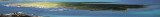
The park begins at Capo Galera to continue toward the gulf of Porto Conte that is protected by two promontories, Punta Giglio and Capo Caccia-Monte Timidone. The marine protected area embraces the stretch of sea to the north-west of Punta Cristallo.Almost all of the park consists ...
Piana Island (23 m high) can ideally be considered as the link between Stintino Peninsula, bordered to the north by Capo Falcone and the island of Asinara. Its name comes from the flatness and surface low and steady. It is close to nearby beaches of Pelosa and Pelosetta, of Stintino. The ...
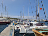
Coordinates WP 40° 56', 12N 08° 13', 97E DescriptionThe harbour Marina of Stintino is located below the jetty of the port of Stintino, is equipped with floating and fixed docks complete with water and electricity DangersShoal in front beacon light, between the coast ...
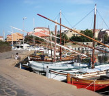
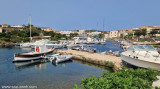
Super small fishing village composed of two deep 'Calas'.
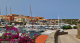
South Porto Minore frequented by fishermen. North Porto Mannu, friendly little marina.Mannu Port: can be used by vessels with 2.3 m Max draft. 300 b. incl. 30 visit.(<13 m) T./F. 523381Mail: stintino@guardiacostiera.itThe ...
The small harbour is located at about 0,9 MN WNW of Punta Negra. It is private, but visitors can found berth towards the end of the breakwater. The club is friendly and the place really nice. The sandy bottom is good holding.Beautiful sandy beach.Depth: de 0,60 à 1,80 m Tel: 079.527085 ...

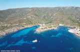


 Punta Negra is the first tip to SE Falcone Cape. It is the end of the S passage of Pelosa. It is low and overwhelmed by rocks.
 Punta Negra est la première pointe au SE du cap Falcone. C'est l'extrémité S du passage de la Pelosa. Elle est basse et débordée par des rochers.
 Punta Negra è la prima punta S capo Falcone.
")
")