La torre delle Saline, is a part of fortified structures which, since the Middle Ages until the mid-nineteenth century, formed the defensive system of warning and communication of Sardinian coast.
The tower is located on the edge of the sea at the north end of the beach of the same name, it is remarkable.
2012/11/22
Update
Joëlle
La torre delle Saline fait partie des structures fortifiées qui, depuis le Moyen Age jusqu'à la moitié du XIXe siècle, formaient le système défensif de l'alerte et de la communication de la côte de la Sardaigne.
La tour est située sur le bord de la mer à l'extrémité nord de la plage du même nom, elle est remarquable.
2012/11/22
Update
Joëlle
La torre delle Saline è una torre che fa parte del complesso di strutture fortificate che, dall'alto medioevo sino alla metà del diciannovesimo secolo, hanno costituito il sistema difensivo, di avvistamento e di comunicazione della fascia costiera della Sardegna.
La torre è situata sulla riva del mare, all'estremità nord dell'omonima spiaggia, è notevole.
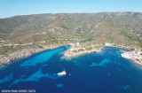
The park begins at Capo Galera to continue toward the gulf of Porto Conte that is protected by two promontories, Punta Giglio and Capo Caccia-Monte Timidone. The marine protected area embraces the stretch of sea to the north-west of Punta Cristallo.Almost all of the park consists ...
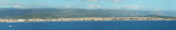
Rada di Alghero is entered between S, the town of Alghero and N, capo Galera.The E shore of this bay is low and sandy, and the W shore is hilly and rocky. An undulating coastal plain, partly under cultivation, lies immediately inland of the head of this bay.This bay is open to ...
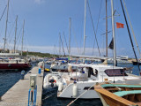
Coordinates WP 40° 56', 12N 08° 13', 97E DescriptionThe harbour Marina of Stintino is located below the jetty of the port of Stintino, is equipped with floating and fixed docks complete with water and electricity DangersShoal in front beacon light, between the coast ...
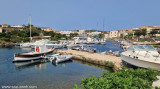
Super small fishing village composed of two deep 'Calas'.
South Porto Minore frequented by fishermen. North Porto Mannu, friendly little marina.Mannu Port: can be used by vessels with 2.3 m Max draft. 300 b. incl. 30 visit.(<13 m) T./F. 523381Mail: stintino@guardiacostiera.itThe ...
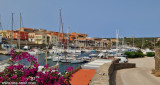
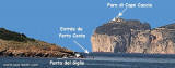
Porto Conte is a natural bay between Punta del Giglio and Caccia cape.Along E shore of the bay, on a projecting point, we see Porto Conte village, with the tower Nuova, which is backed by a turret with a light.You can anchor anywhere. The bay offers shelter from all winds. Mount ...


 La torre delle Saline, is a part of fortified structures which, since the Middle Ages until the mid-nineteenth century, formed the defensive system of warning and communication of Sardinian coast.
 La torre delle Saline fait partie des structures fortifiées qui, depuis le Moyen Age jusqu'à la moitié du XIXe siècle, formaient le système défensif de l'alerte et de la communication de la côte de la Sardaigne.
 La torre delle Saline è una torre che fa parte del complesso di strutture fortificate che, dall'alto medioevo sino alla metà del diciannovesimo secolo, hanno costituito il sistema difensivo, di avvistamento e di comunicazione della fascia costiera della Sardegna.
")
")