The village of Stintino was founded in 1885 by the ex-inhabitants of the island of Asinara, who were evicted after the founding of a penal colony on the island.
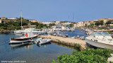
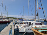
There are two ports at Stintino, Porto Nuovo and Porto Vecchio. Both are able to host all kinds of boats and provide the services connected to sailing. Some piers host the boats equipped for travelling tourist excursions and for the Asinara island.
2012/11/21
Update
Joëlle
Super petit village de pêcheurs composé de deux 'calas' profondes.
Au sud Porto Minore fréquenté par les pêcheurs.
Au nord Porto Mannu, petite marina sympathique.
Port Mannu: ne peut être utilisé que par les bateaux avec 2,3m maxi de tirant d'eau.
Porto Stintino sorge su una penisola che separa l'insenatura Sud (Porto Minore) da quella Nord (Porto Mannu). Porto Mannu: puo essere utilizzato solo da barche con pescaggio massimo di 2,3m.
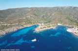
The park begins at Capo Galera to continue toward the gulf of Porto Conte that is protected by two promontories, Punta Giglio and Capo Caccia-Monte Timidone. The marine protected area embraces the stretch of sea to the north-west of Punta Cristallo.Almost all of the park consists ...
Coordinates WP 40° 56', 12N 08° 13', 97E DescriptionThe harbour Marina of Stintino is located below the jetty of the port of Stintino, is equipped with floating and fixed docks complete with water and electricity DangersShoal in front beacon light, between the coast ...
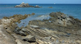
Piana Island (23 m high) can ideally be considered as the link between Stintino Peninsula, bordered to the north by Capo Falcone and the island of Asinara. Its name comes from the flatness and surface low and steady. It is close to nearby beaches of Pelosa and Pelosetta, of Stintino. The ...
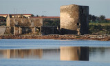
La torre delle Saline, is a part of fortified structures which, since the Middle Ages until the mid-nineteenth century, formed the defensive system of warning and communication of Sardinian coast.
The tower is located on the edge of the sea at the north end of the beach ...


 Bonne tenue
 Bonne tenue
 canal 16


")
 Super small fishing village composed of two deep 'Calas'.
 Super petit village de pêcheurs composé de deux 'calas' profondes.
 Porto Stintino sorge su una penisola che separa l'insenatura Sud (Porto Minore) da quella Nord (Porto Mannu).
")
")