Otok Ciovo
5.8nm
265°
O. Ciovo forms the SW side of the entrance and inner part of Kastelanski Zaliv.
At East side, Ciovo is 2km from ...
7 Aug 11
cdg2
| Latitude | Longitude | |
| DMS | --- | --- |
| DM | --- | --- |
| DD | --- | --- |


 The main feature of this port city is quite disturbing: the old town lies within the remains of a palace that belonged to one of the last Roman emperors.
Tel: +385 (0)21 398 599
Fax: +385 (0)21 398 556
Mail: m.split@aci-club.hr
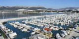
364 b.
60 b. dry

 La principale particularité de cette ville portuaire est assez
troublante : la vieille ville est située à l'intérieur des restes d'un
palais ayant appartenu à l'un des derniers empereurs romains.
La principale particularité de cette ville portuaire est assez
troublante : la vieille ville est située à l'intérieur des restes d'un
palais ayant appartenu à l'un des derniers empereurs romains.Le port du sud (Gradska Luka) est ouvert au sud et peu de fois par an (fin de l'automne, l'hiver, au début du printemps) de forts vents du sud-ouest (Lebic) peuvent augmenter la hauteur de la mer à 1 ½ - 2 m dans le port, provoquant des vagues passant par dessus le mur nord du port. Cette condition est normalement de courte durée (plus ou moins 4-5 heures), après quoi la mer se calme très rapidement. Une grande partie du port est protégée de tels vents de sorte qu'il est possible de déplacer les navires plus près de la digue de l'Est (Lukobran) et d'éviter de graves dommages.
* La bora peut souffler très fort dans Gradska Luka, avec des rafales jusqu'à 90 nœuds. Toutefois, cela n'est pas considéré comme dangereux pour les navires immobilisés dans le port. Les navires de tourisme, dans des conditions bora, sont amenés plus près du côté nord du port, car les rafales plus fortes vont à la digue Sud.
* Le jugo, ou scirocco, soulève une mer à l'ouest de Gradska Luka, touchant de petits bateaux, qui doivent être déplacés pour une meilleure protection à d'autres endroits dans le port. Toutefois, les grands navires sont en sécurité, quand souflent les vents les plus forts du sud-est, à leurs emplacements à la jetée E.
* Gradska Luka n'a jamais été contraint de fermer en raison des conditions météorologiques. Même pendant les vents les plus graves, il est possible pour les grands navires d'entrer ou de quitter la zone portuaire. Les petits bateaux, bien sûr, doivent doivent être prudents au cours de tels événements, tant à l'intérieur qu'à l'extérieur de l'entrée du port.
Tel: +385 (0)21 398 599
Fax: +385 (0)21 398 556
Mail: m.split@aci-club.hr
364 b.
60 b. dry


Ebook | Splitsko-dalmatinska županija (Split-Dalmatia Coun
|
Ebook | Dalmacija (Dalmatie)
|