Ciovo is an island in the center of the Dalmatian archipelago. This is an area of 28.8 acres (15.3 km length, width of 3.5 km). It culminates at 218 m (Mount Rudin). O. Ciovo forms the SW side of the entrance and inner part of Kastelanski Zaliv. At East side, Ciovo is 2km from ...
Otok Zirje
is the farthest and the largest island in the Sibenik archipelago. It is long of 6,5 NM (NW/SE) and 1,4 NM wide. The main village, Zirje, is located in the middle of the island. A small port, luka Muna, on the coast N of Zirje, home to the ferry that connects the ...
Otok Svetac (Andrija), 305m high, lies 13 miles ESE of Otocic Jabuka and is generally steep-to. The coast of the island is rocky and reddish in color on the NW side. Its SW end is fronted by a few rocks. Hrid Kamik, a dark and jagged above-water rock, lies 0.7 mile W of the SW extremity ...
Plakeni islands, or Cursed Islands, are located at the W and S of Hvar town.
The islands are rocky, covered with bushes and trees. They are usually deserted, except in summer. They offer many choices of moorings sheltered and there is a marina Palmizana.The islands'name ...
Very close to Drvenik Veli (1 M), Drvenik Mali, the W Drvenik Veli, made 2 M in E and W 1 M to its widest point. The coast is cut and the sea around the island is shallow. Its highest point is 79 meters high. There is a small port on the NE coast of the island. The ...


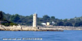
 Island accessible only by sea. It is long about 3 m long by 2 m wide. It is 2 M NW of otok Solta.
 Île accessible uniquement par la mer. Elle est longue d'environ 3 M de long par 2 M de large. Elle se trouve à 2 M au NW d'otok Solta.