Marinas Spinut Kastelanski Zaljev

Marinas Spinut Kastelanski Zaljev

To precisely geolocate this site. Update if necessary.

Localisation

Characteristics

Port
Mud
Sand
VHF canal 17
Water
Electricity
Fuel face à l'hôtel Marjan
Mechanical repair
Shipyard
Slip
Parking
Shower
WC
Market
Grocery
Restaurant
Bank
North Cardinal
Isolated danger
Beach
Sand

Description

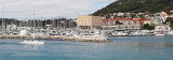
On the SE coast of Kastelanski Zaljev, in Poljud luka, are two adjacent marinas, held by sailing clubs.
The W marina is managed by DSP Spinut and marina E by Split SDB.
Approach: Entering the bay attention to the green buoy located N of Rt Marjan. It is forbidden to go inside the buoy.
With the approach of marinas careful at Plic Garifulin, indicated by a beacon without fire, and Hrid Skoljic, reported by a fire (see map).
N of the bay, watch Plic Galija (N cardinal buoy with fire), Greben Galija (beacon without fire) and Hrid Galija (sector light), Plic Shiloh to E Hrid Galija (beacon with fire). Do not pass too close to Rt Rat (pointe E of Hrid Skoljic) due to overflowing with rocks.
Entry Luka Lora is prohibited.
It docks to one of two marinas.
Good shelter.
770 b.
Tel: +385 21 386 761
Fax: +385 21 583 805


2011/06/6
Update
Jojo
Marinas Spinut Kastelanski Zaljev
2011-06-06
Update
Jojo
Sur la côte SE de Kastelanski Zaljev, dans luka Poljud, se trouvent deux marinas adjacentes, tenues par des clubs de voile.
Le port de plaisance W est administré par PSD Spinut et celui d'E par RPSD Split.

Approche: en entrant dans la baie, attention à la bouée verte située au N de Rt Marjan. Il est interdit de passer à l'intérieur de cette bouée.
A l'approche des ports de plaisance attention à Plic Garifulin, signalé par une balise sans feu, et à Hrid Skoljic, signalé par un feu. (voir la carte).

Au N de la baie, attention à Plic Galija (bouée cardinale N avec feu), Greben Galija (balise sans feu) et Hrid Galija (feu à secteurs), Plic Silo à l'E d'Hrid Galija (balise avec feu). Ne pas passer trop près de Rt Rat (pointe E de Hrid Skoljic) à cause de rochers débordants.
L'entrée de Luka Lora est interdite.

On s'amarre à l'une des deux marinas.

Bon abri.

770 pl.
Tel: +385 21 386 761
Fax: +385 21 583 805


2011/06/6
Update
Jojo
Marinas Spinut Kastelanski Zaljev
2011-06-06
Update
Jojo
Ebook

Splitsko-dalmatinska županija (Split-Dalmatia Coun

  • 155 sites
  • 295 photos
  • publication date: 6 Jul 2023
  • .pdf file size: 97 Mb
Ebook

Dalmacija (Dalmatie)

  • 542 sites
  • 910 photos
  • publication date: 9 Jul 2023
  • .pdf file size: 302 Mb
Share your comments or photos on "Marinas Spinut Kastelanski Zaljev"

Sites around Marinas Spinut Kastelanski Zaljev

Flying distances - Direct line

Otok Ciovo

5.5nm
256°
Ciovo is an island in the center of the Dalmatian archipelago. This is an area of 28.8 acres (15.3 km length, width of 3.5 km). It culminates at 218 m (Mount Rudin).
O. Ciovo forms the SW side of the entrance and inner part of Kastelanski Zaliv.
At East side, Ciovo is 2km from ...
7 Aug 11
cdg2

Otoci Pakleni

21nm
184°
Plakeni islands, or Cursed Islands, are located at the W and S of Hvar town.

The islands are rocky, covered with bushes and trees. They are usually deserted, except in summer.
They offer many choices of moorings sheltered and there is a marina Palmizana.The islands'name ...
26 May 11
Jojo

Starogradski Zaljev Hvar

20nm
163°
Starogradski is a large deep bay, open to the NW, which houses the city and the port of Stari Grad on its SE end.
There are several bays, including its N side, where it is possible to anchor. On the other side there is an anchor in front Gradisce.
31 May 11
Jojo

Pakleni Kanal

20nm
184°
Pakleni Kanal lies between Pakleni Otoci and Otok Hvar.
It is a deep and wide channel, with access at both ends, which leads to Luka Hvar.
This channel is frequented by small vessels with local knowledge and affords good shelter from the bora, although heavy squalls may be encountered.
The ...
30 May 11
Jojo

Split marina

0.9nm
153°
The main feature of this port city is quite disturbing: the old town lies within the remains of a palace that belonged to one of the last Roman emperors.
The south port (Gradska Luka) is open to the south and a few times a year (late fall, winter, early spring) strong southwesterly ...
3 Apr 11
Jojo

Otok Drvenik Veli

12nm
248°
Island accessible only by sea. It is long about 3 m long by 2 m wide. It is 2 M NW of otok Solta.Its area is 12.07 km ² and its highest point is 178 m.It is separated from the mainland by Drvenicki Kanal.
The coast of this beautiful island has remained intact and is made of many ...
18 Aug 11
Croatia