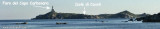
Secca dei Berni lies 1.5 miles SSW of Punta Molentis. It is marked by a lighted beacon. This shoal patch has a least depth of 2.4m at its N end.
You can dive to admire the ruins of a Roman galley.
2012/10/14
Update
Joëlle
Secca dei Berni se trouve à 1,5 MN de la pointe Molentis. Ce haut-fond est indiqué par une balise lumineuse. Il a une profondeur minimale de 2,4 m à son extrémité N. On peut admirer les ruines d'une galère romaine en plongée.
2012/10/14
Update
Joëlle
Secca dei Berni si trova 1,5 MN SSW da Punta Molentis. E' caratterizzata da un faro illuminato. Questa secca ha una profondità di almeno 2,4 m alla sua estremità N.
Si possono ammirare i resti di una galea romana in immersioni.
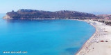
Carbonara gulf is located between Carbonara cape and Boi cape, in the Cagliari gulf, on its E side.Depending on the wind,we anchor on the W or E side of the bay. This large bay, rock and sand bottom, is very pretty and very crowded in summer. NW of Carbonara cape, Carbonara Bay ...
Quartu gulf lies between Foxi tower and S. Elia cape, in the Cagliari Gulf.It is not recommended to anchor in the Quartu bay.Ancorage is also prohibited in a strip between the bearings to 314 ° of Mezza Spiaggia tower and 316 ° to the S. Elia E end cape and extending to 7 NM of shore.
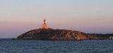
Cavoli island is low and partly covered with bushes. It has a lighthouse with a radio beacon. The island is located 0.3 NM SE of Carbonara Cape, it is surrounded by rocks and shoals, which greatly reduces the width of the passage between it and the cape.
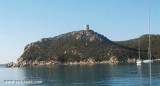
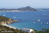
Porto Giunco bight is entered between Punta Molenti and Capo Carbonara. Giunco tower, partly in ruins,stands on the summit of a small promontory, 64m high, 1 mile N of Capo Carbonara.Anchorage can be taken, in a depth of 18m, sand and weed, about 0.7 mile ENE of this tower, between ...
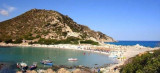
Molentis (dei Molenti) point, 2 NM W S of Serpentara island, end consists of a small headland surrounded by rocks and low, connected to the mainland by a sandbar.
Ancorage by 26 m about halfway between the Molentis tipand Serpentara island.


 Secca dei Berni lies 1.5 miles SSW of Punta Molentis. It is marked by a lighted beacon. This shoal patch has a least depth of 2.4m at its N end.
 Secca dei Berni se trouve à 1,5 MN de la pointe Molentis. Ce haut-fond est indiqué par une balise lumineuse. Il a une profondeur minimale de 2,4 m à son extrémité N.
 Secca dei Berni si trova 1,5 MN SSW da Punta Molentis. E' caratterizzata da un faro illuminato. Questa secca ha una profondità di almeno 2,4 m alla sua estremità N.
")
")