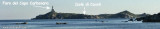
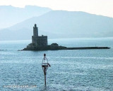
Cavoli island is low and partly covered with bushes. It has a lighthouse with a radio beacon. The island is located 0.3 NM SE of Carbonara Cape, it is surrounded by rocks and shoals, which greatly reduces the width of the passage between it and the cape.
It is forbidden to anchor in this passage because of the presence of submarine cables.
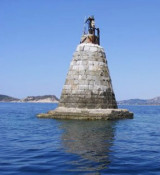
A 1.5 M W of the island, Secca di San Caterina (Secca di Cala Caterina), covered under 5 m of water, is marked at NE by a red buoy.
2012/10/15
Update
Joëlle
Isola dei Cavoli (Villasimius Sardegna)
2012-10-15
Update
Joëlle
The island of Cavoli is low and partly covered with bushes. The island is at 0.3 MN to the SE of Cape Carbonara, it is surrounded by rocks and shoals, which considerably reduces the width of the passage between it and the cape. It is forbidden to anchor in this passage due to the presence of submarine cables.
At 1.5 M to the W of the island, the rocky shoal of Cala Caterina, covered under 5 m of water, is marked NE by a red buoy.
2017/09/23
Update
Joëlle
L'île dei Cavoli est peu élevée et partiellement couverte de buissons. Elle porte un phare avec radiophare. L'île se trouve à 0,3 MN au SE de cap Carbonara, elle est entourée de rochers et de hauts-fond, ce qui réduit considérablement la largeur du passage entre elle et le cap.
Il est interdit de mouiller dans ce passage à cause de la présence de cables sous-marins.
A 1,5 M à l'W de l'île, le hauts-fond rocheux de cala Caterina, couvert sous 5 m d'eau, est balisé au NE par une bouée rouge.
2012/10/15
Update
Joëlle
L'isola dei Cavoli è bassa e in parte coperto di cespugli. Ha un faro con un radiofaro. L'isola si trova a 0,3 NM SE di Capo Carbonara, è circondata da rocce e da secca che riduce notevolmente la larghezza del passaggio tra esso e il capo.
È vietato di ancorare in questo passaggio per la presenza di cavo sottomarino.
A 1,5 M W dell'isola, la secca Caterina cala Caterina coperti da 5 m di acqua, è caratterizzato da una boa rossa NE.
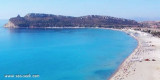
Carbonara gulf is located between Carbonara cape and Boi cape, in the Cagliari gulf, on its E side.Depending on the wind,we anchor on the W or E side of the bay. This large bay, rock and sand bottom, is very pretty and very crowded in summer. NW of Carbonara cape, Carbonara Bay ...
Quartu gulf lies between Foxi tower and S. Elia cape, in the Cagliari Gulf.It is not recommended to anchor in the Quartu bay.Ancorage is also prohibited in a strip between the bearings to 314 ° of Mezza Spiaggia tower and 316 ° to the S. Elia E end cape and extending to 7 NM of shore.
Secca dei Berni lies 1.5 miles SSW of Punta Molentis. It is marked by a lighted beacon. This shoal patch has a least depth of 2.4m at its N end.
You can dive to admire the ruins of a Roman galley.
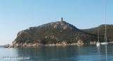
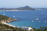
Porto Giunco bight is entered between Punta Molenti and Capo Carbonara. Giunco tower, partly in ruins,stands on the summit of a small promontory, 64m high, 1 mile N of Capo Carbonara.Anchorage can be taken, in a depth of 18m, sand and weed, about 0.7 mile ENE of this tower, between ...
The shoal, W Cala Caterina, is covered by 5 m of water. It is marked at NE by a red buoy. It is a famous point for diving where you can see two modern anchors surrounded by a multitude of fishes, sponges, yellow and white and Posidonia.


 Cavoli island is low and partly covered with bushes. It has a lighthouse with a radio beacon.
")
 L'île dei Cavoli est peu élevée et partiellement couverte de buissons. Elle porte un phare avec radiophare.
 L'isola dei Cavoli è bassa e in parte coperto di cespugli. Ha un faro con un radiofaro.
")