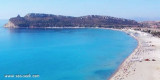
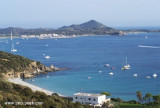
Molentis (dei Molenti) point, 2 NM W S of Serpentara island, end consists of a small headland surrounded by rocks and low, connected to the mainland by a sandbar.
Ancorage by 26 m about halfway between the Molentis tipand Serpentara island.
2012/10/14
Update
Joëlle
La pointe Molentis (dei Molenti), à 2 MN à l'W de l'extrémité S de l'île Serpentara, est constituée par un petit promontoire bas et entouré de roches, relié à la côte par une langue de sable.
On peut ancrer par 26 m environ à mi-distance entre la pointe Molentis et l'île Serpentara.
2012/10/14
Update
Joëlle
Punta Molentis (dei Molenti), 2 MN W dell'estremita dell'isola Serpentara, è costituito da un piccolo promontorio circondato da rocce e collegate alla terraferma da una lingua di sabbia.
Si puo ancorare da 26 m circa a metà strada tra la punta Molentis e e l'isola Serpentara.
Carbonara gulf is located between Carbonara cape and Boi cape, in the Cagliari gulf, on its E side.Depending on the wind,we anchor on the W or E side of the bay. This large bay, rock and sand bottom, is very pretty and very crowded in summer. NW of Carbonara cape, Carbonara Bay ...
Quartu gulf lies between Foxi tower and S. Elia cape, in the Cagliari Gulf.It is not recommended to anchor in the Quartu bay.Ancorage is also prohibited in a strip between the bearings to 314 ° of Mezza Spiaggia tower and 316 ° to the S. Elia E end cape and extending to 7 NM of shore.
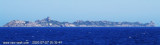
Serpentara island is 1,7 NM off the coast. It is flat and bare and N is extended by a shoal which emerge 3 large rocks. You can anchor between the island and the earth, at 1 NM SSW Cala Pira tower.
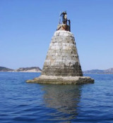
Secca dei Berni lies 1.5 miles SSW of Punta Molentis. It is marked by a lighted beacon. This shoal patch has a least depth of 2.4m at its N end.
You can dive to admire the ruins of a Roman galley.
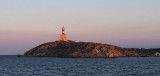
Cavoli island is low and partly covered with bushes. It has a lighthouse with a radio beacon. The island is located 0.3 NM SE of Carbonara Cape, it is surrounded by rocks and shoals, which greatly reduces the width of the passage between it and the cape.


 Molentis (dei Molenti) point, 2 NM W S of Serpentara island, end consists of a small headland surrounded by rocks and low, connected to the mainland by a sandbar.
 La pointe Molentis (dei Molenti), à 2 MN à l'W de l'extrémité S de l'île Serpentara, est constituée par un petit promontoire bas et entouré de roches, relié à la côte par une langue de sable.
 Punta Molentis (dei Molenti), 2 MN W dell'estremita dell'isola Serpentara, è costituito da un piccolo promontorio circondato da rocce e collegate alla terraferma da una lingua di sabbia.
")
")
")