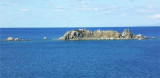
Carbonara cape is located at the S end of the rocky peninsula connected to the mainland by a low sandy isthmus.
A beacon of 5 m high is 0.7 MN NNW at the end of the cape.
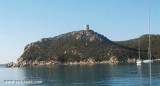
The cape offers moorings on both sides. It is dominated by the tower Caterina where we see the old semaphore. The W coast of the peninsula is very cut and overwhelmed by rocks surrounded by high-background.
Opposite direction, about 800 m SE, lies the Cavoli island.
Natural Reserve of Carbonara Cape
ZONE A: Integral Reserve
Are prohibited: The import or export of minerals and geological materials Navigation and boat access fishing Underwater fishing
ZONE B: General Reserve
are prohibited: The anchor free Freedom of navigation engine Underwater fishing
Are allowed: navigation at low speed Occupational or recreational fishing
ZONE C: Partial Reserve:
Are prohibited: The anchor free underwater fishing
2014/05/7
Update
Joëlle
Réserve naturelle Di Capo Carbonara
La ZONE A: Réserve intégrale
Sont interdits:
L'importation ou l'exportation de matériaux géologiques et minéraux
La navigation et l'accès des bateaux
la pèche
La pèche sous-marine
La ZONE B: Réserve générale
sont interdits:
L'ancrage libre
La liberté de la navigation à moteur
La pèche sous-marine
Sont permis:
la navigation à petite vitesse
La pèche professionnelle ou sportive
La ZONE C: Réserve partielle:
Sont interdits:
L'ancrage libre
la pèche sous-marine
2012/10/14
Update
Joëlle
Le Cap Carbonara est situé à l'extrémité S de la presqu'île rocheuse reliée à la terre par un isthme de sable très bas.
Un phare de 5 m de haut s'élève à 0,7 MN au NNW de l'extrémité du cap.
Le cap offre des mouillages sur ses deux versants. Il est dominé par la tour Caterina où l'on voit l'ancien sémaphore. La côte W de la presqu'île est très découpée et débordée par des rochers entourés de hauts-fond.
En face du cap, à environ 800 m au SE, se trouve l'île des Cavoli.
2014/05/7
Update
Joëlle
Capo Carbonara si trova alla fine S della penisola rocciosa collegata alla terraferma da un istmo di sabbia bassa.
Un faro di 5 m di altezza è di 0,7 MN si erge a 0,7 MN NNW della fine del capo.
Il capo offre ormeggi sulle due lati del capo. E 'dominato dalla torre di Caterina dove si vede il vecchio semaforo.
La costa W della penisola è molto tagliata e sopraffatta circondate da rocce da circondate da banchi.
Di fronte al capo, a circa 800 m SE, si trova l'isola dei Cavoli.
Riserva Naturale di Capo Carbonara:
ZONA A: Riserva Integrale
Sono vietate: L'importazione o l'esportazione di minerali e materiali geologici Di navigazione e di accesso barca pesca Pesca subacquea
ZONA B: Riserva Generale
sono vietati: L'ancora libero Libertà di navigazione motore Pesca subacquea
Sono consentiti: la navigazione a bassa velocità Pesca professionale e ricreativa
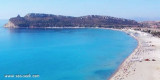
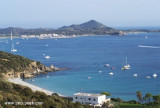
Carbonara gulf is located between Carbonara cape and Boi cape, in the Cagliari gulf, on its E side.Depending on the wind,we anchor on the W or E side of the bay. This large bay, rock and sand bottom, is very pretty and very crowded in summer. NW of Carbonara cape, Carbonara Bay ...
Quartu gulf lies between Foxi tower and S. Elia cape, in the Cagliari Gulf.It is not recommended to anchor in the Quartu bay.Ancorage is also prohibited in a strip between the bearings to 314 ° of Mezza Spiaggia tower and 316 ° to the S. Elia E end cape and extending to 7 NM of shore.
The shoal, W Cala Caterina, is covered by 5 m of water. It is marked at NE by a red buoy. It is a famous point for diving where you can see two modern anchors surrounded by a multitude of fishes, sponges, yellow and white and Posidonia.
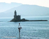
Porto Giunco bight is entered between Punta Molenti and Capo Carbonara. Giunco tower, partly in ruins,stands on the summit of a small promontory, 64m high, 1 mile N of Capo Carbonara.Anchorage can be taken, in a depth of 18m, sand and weed, about 0.7 mile ENE of this tower, between ...
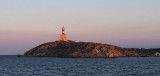
Cavoli island is low and partly covered with bushes. It has a lighthouse with a radio beacon. The island is located 0.3 NM SE of Carbonara Cape, it is surrounded by rocks and shoals, which greatly reduces the width of the passage between it and the cape.


")
")
")
")
 Carbonara cape is located at the S end of the rocky peninsula connected to the mainland by a low sandy isthmus.
 Capo Carbonara si trova alla fine S della penisola rocciosa collegata alla terraferma da un istmo di sabbia bassa.