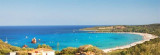
Golfo di Tortoli (Sardegna)
6.8nm
3°
Winds from the NW and NE quadrants come up suddenly and blow with extreme violence in this vicinity.
They may last for 4 or 5 days and are preceded by whitish clouds ...
10 Oct 12
Joëlle
| Latitude | Longitude | |
| DMS | --- | --- |
| DM | --- | --- |
| DD | --- | --- |


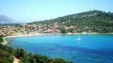
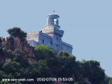
 The Bari tower, remarkable, is an ancient medieval tower on the east coast of Sardinia, in the province of Ogliastra, 4.5 km from the city of Bari Sardo.
The tower was built in the area of Bari in 1572, because the site was frequented by pirates. The tower is built with granite rocks and basalt premises. Tapered, it has a height of about 13 m and a diameter of about 11 m and 8 m at the base. Inside there is a small circular room about 14 m2.
The tower was used to observe and control with a focal length of 15 km, the area stretching between Bellavista Cape and SferracavalloCape, but also the mouth of the Rio Mannu, a place enjoyed to pirates for water supply.
The wreck of a twin engine felled by the Germans during the war against Arbatax, crashed off the coast of Torre di Bari ... It was difficult to find it in the middle of the wide sandy bottom but ... it is fantastic to explore ..
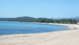
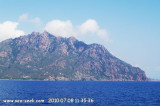
Between Capo Bellavista and Capo Sferracavallo, the coast alternates in high rocky stretches and low, sandy, and marshy stretches.
")
 La Torre di Bari, remarquable, est une ancienne tour médiévale située sur la côte est de la Sardaigne, dans la province de l'Ogliastra, à 4,5 km de la ville de Bari Sardo.
La tour a été construite dans la zone de Bari en 1572, parce que le site a été fréquenté par des pirates. La tour est construite avec des rochers de granit et de basalte locaux. De forme tronconique, elle a une hauteur d'environ 13 m et un diamètre d'environ 11 m et 8 m à la base. A l'intérieur il y a une petite pièce circulaire d'environ 14 m2.
La tour servait à observer et surveiller, avec une focale de 15 km, la zone qui s'étend entre le cap Bellavista et le cap Sferracavallo, mais également l'embouchure du Rio Mannu, un lieu cher aux pirates pour l'approvisionnement en eau.
L'épave d'un bimoteur abattu par les allemands lors de la guerre contre Arbatax, s'est écrasé au large de la côte de Torre di Bari ...Il a été difficile de la trouver au milieu de l'imense fond de sable...mais c'est fantastique à explorer..
Entre Capo Bellavista et capo Sferracavallo, la côte est alternée par de hautes étendues rocheuses et de basses étendues sablonneuses et marécageuse.
")
 La Torre di Barì, notevole, è un'antica torre medioevale posta sulla costa orientale della Sardegna, nella provincia dell'Ogliastra, a 4,5 Km dal centro abitato di Bari Sardo.
La Torre di Barì sorge su un piccolo promontorio roccioso, che avanza dalla linea di costa, ed è orlata da una spiaggia sabbiosa, chiamata spiaggia di Barì.
La torre è stata costruita nella zona di Barì, nel 1572, poiché quel sito risultava molto frequentato dai corsari. La torre è costruita con rocce granitiche e basaltiche locali. Di forma
troncoconica, ha un'altezza di circa 13 m e un diametro di circa 11 m
alla base e 8 m al terrazzo. All'interno è presente una piccola camera
circolare di circa 14 m2.
Come è presumibile, la torre aveva funzioni di vedetta e, con una visuale di 15 km, osservava la zona che si estende da Capo Bella Vista a Capo Sferracavallo; controllava anche la foce del Rio Mannu, meta cara ai pirati per l'approvvigionamento idrico.
Un relitto di un bimotore abbattuto dalla contraerea tedesca di Arbatax e precipitato a largo di Torre di Barì... E' stato difficile trovarlo in mezzo all'enorme fondale sabbioso...ma fantastico esplorarlo..
Tra Capo Bellavista e Capo Sferracavallo, la costa sialternano alti tratti rocciosi e bassi tratti sabbiosi e paludose.
") L'épave de Bari
L'épave de Bari") Les rochers devant la tour
Les rochers devant la tourEbook | Sardegna East
|