Safe Harbor (Stock Island)

Safe Harbor (Stock Island)

To precisely geolocate this site. Update if necessary.

Localisation

Characteristics

Port
VHF canal 16
Ice
Water
Electricity
Fuel
Mechanical repair
Shipyard 60 T
Slip
WC

Description

Safe Harbor (Stock Island)
2010-02-22
Update
Joëlle
Safe Harbor (Stock Island)
2010-02-22
Update
Joëlle
Safe Harbor (Stock Island)
2010-02-22
Update
Joëlle
Ebook

Gulf of Mexico

  • 227 sites
  • 182 photos
  • publication date: 9 Jul 2023
  • .pdf file size: 78 Mb
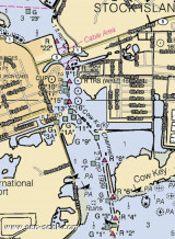
Safe Harbor, 4 miles E of Key West, is a medium- draft harbor on the S side of Stock Island.
Conspicuous objects include the stack and tanks at a powerplant and desalination plant on the E side of the harbor, and a large red dry storage building at a marina on the SE end of Stock Island.
A privately dredged channel leads from Hawk Channel into the harbor.
Piers with dolphins on the E side of the harbor near the entrance are used by barges to unload petroleum products for the power and desalination plants.
Depths: 18 feet.

The piers on the E and W sides of the harbor are used by cold storage and seafood packing plants; numerous shrimp boats tie up alongside the finger piers.

Boatyard on the W side at the head of the harbor.

A privately dredged spur channel E of Safe Harbor leads to a large marina on the SE end of Stock Island. In
April 1982, a reported controlling depth of 18 feet was available to the facility.

Tel: 305-509-4072
Mail: ljohn@sprynet.com

2010/03/7
Update
Alain
Situé à 4 M à l'E de Key West, au S de Stock Island.

Un entassement de citernes, motopropulseur et une usine de dessalinisation se trouvent sur le côté E du port, ainsi qu'un grand bâtiment rouge de stockage à sec à l'extrémité SE.
Un canal privé mène de Hawk Channel au port.

Des piliers avec des pontons sur le côté E, à l'entrée du port, sont utilisés par les barges de déchargement de produits pour l'énergie et les usines de dessalement.
Profondeur: 6 m

Les piliers à l'E et l'W du port, sont utilisé par les entrepôts frigorifiques et les usines de conditionnement de poisson. De nombreux bateaux de pêche sont accostés aux appontements.

Chantier à l'W du port.

Un canal privé et balisé conduit à une grande marina à l'extrémité SE de l'île de Stock.

Tel: 305-509-4072
Mail: ljohn@sprynet.com

2010/03/7
Update
Alain
Share your comments or photos on "Safe Harbor (Stock Island)"

Sites around Safe Harbor (Stock Island)

Flying distances - Direct line

Boca Chica Key Key West NAS (Florida Keys)

2.3nm
68°
Boca Chica Key is an island in the lower Florida Keys approximately 3 miles east of the island of Key West.
Its name is Spanish for "small mouth", (not "girl mouth" as many assume, since chica used as an adjective in Spanish means small).It is mainly composed of salt marshes (mangroves) ...
15 Apr 10
Joëlle

Marquesas Keys (Florida)

21nm
270°
The Marquesas Keys (not to be confused with the Marquesas Islands (French Polynesia in the Pacific Ocean) form an uninhabited island group about 30 miles (50 km) west of Key West, 4 miles (6 km) in diameter, and overgrown by mangrove. They are protected as part of the Key ...
8 Apr 12
Cham

Stock Island (Florida Keys)

0.5nm
340°
Stock Island is an island in the lower Florida Keys immediately east of Key West (separated from Key West by Cow Key Channel, which is only about 75 yards (70 m) wide).Immediately northwest is Key Haven (official name Raccoon Key), from which it is connected by causeway with US 1 ...
19 Mar 10
Joëlle

Racoon Key (Key Haven) (Florida Keys)

1nm
Key Haven is an unincorporated community on Raccoon Key, an island in the lower Florida Keys about a mile east of the island of Key West. It is a suburb of greater Key West.
19 Mar 10
Joëlle

Sigsbee Park (Dragues Key) (Florida Keys)

2.2nm
294°
Sigsbee Park, also known as Dredgers Key, is an island about a half mile north of Key West island. It is connected to the island of Key West by Sigsbee Road. The island and causeway are part of the Key West Naval Air Station. It is primarily used for Navy housing.
It also includes ...
19 Mar 10
Joëlle

Cow Key Channel (Key West)

0.6nm
263°
Cow Key Channel, between Stock Island and Key West, is narrow and and marked by private daybeacons.Caution: A shoal that bares is about 0.2 mile SSW of the SW point of Cow Key.
It was reported that the channel was subject to frequent change. Mariners are advised to seek local knowledge ...
7 Mar 10
Bjplan