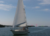
Sigsbee Park, also known as Dredgers Key, is an island about a half mile north of Key West island.
It is connected to the island of Key West by Sigsbee Road. The island and causeway are part of the Key West Naval Air Station. It is primarily used for Navy housing. It also includes a Navy Exchange, commissary, elementary school, marina, child development center, youth center, recreation center, RV park, veterinary clinic and Sunset Lounge bar & grill.
The island was created in the 1940s from dredge spoil following the construction of Navy seaplane runways supporting the former seaplane base at nearby Trumbo Point.
2010/03/19
Update
Joëlle
Sigsbee Park, également connue sous le nom, Dragues Key est une île qui se trouve à environ 1 M de la moitié N de Key West.
Elle est reliée à l'île de Key West par Sigsbee Road. L'île et la chaussée font partie de la Key West Naval Air Station. Elle est principalement utilisée pour le logement de la Marine. Elle comprend également un échange de la Marine, commissaire, l'école élémentaire, marina, centre de développement de l'enfant, un centre jeunesse, centre de loisirs, terrain de caravaning, de la clinique vétérinaire et Sunset Lounge bar & grill.
L'île a été créée dans les années 1940 à partir de résidus de dragage après la construction de pistes d'hydravions de la Marine soutenir l'hydravion ancienne base situé à proximité de Point Trumbo.
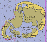
The Marquesas Keys (not to be confused with the Marquesas Islands (French Polynesia in the Pacific Ocean) form an uninhabited island group about 30 miles (50 km) west of Key West, 4 miles (6 km) in diameter, and overgrown by mangrove. They are protected as part of the Key ...
Boca Chica Key is an island in the lower Florida Keys approximately 3 miles east of the island of Key West. Its name is Spanish for "small mouth", (not "girl mouth" as many assume, since chica used as an adjective in Spanish means small).It is mainly composed of salt marshes (mangroves) ...
Stock Island is an island in the lower Florida Keys immediately east of Key West (separated from Key West by Cow Key Channel, which is only about 75 yards (70 m) wide).Immediately northwest is Key Haven (official name Raccoon Key), from which it is connected by causeway with US 1 ...
Fleming Key is an island off the northwest corner of the island of Key West, Florida in the lower Florida Keys. It is roughly 2 miles (3.2 km) long by a quarter mile wide. It is connected to the island of Key West by the Fleming Key Bridge. The island and bridge ...
Key Haven is an unincorporated community on Raccoon Key, an island in the lower Florida Keys about a mile east of the island of Key West. It is a suburb of greater Key West.
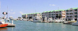
Marina located along the northwestern banks of Stock Island, east-southeast of charted Sigsbee Park. Phone: (305) 296-7101 Fax: (305) 296-0798 Mail: dockmaster@sunsetmarinakw.com Minimum depth: 7 feet


 Sigsbee Park, also known as Dredgers Key, is an island about a half mile north of Key West island.
  Sigsbee Park, également connue sous le nom, Dragues Key est une île qui se trouve à environ 1 M de la moitié N de Key West.