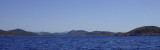
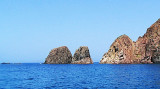
Cala d'Aligusta is between Teulada cape and d'Aligusta point, to W side of cape. It is inside the military polygon of Teulada cape.
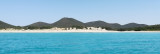
It is a very small cove, very open to W winds. The small pebble beach is full of fragments brought by the storms.
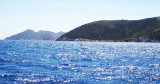
La cala d'Aligastro has a cave that that you can visit during the dive.
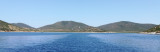
Anchorage in about 10 m.
2012/10/25
Update
Joëlle
Cala d'Aligusta se trouve entre le cap Teulada et la pointe d'Aligusta, sur la côte W du cap. Elle est à l'intérieur du polygone militaire du cap Teulada.
C'est une toute petite anse, très exposée aux vents d'W. La petite plage de galets est pleine de débris apportés par les tempêtes.
A l'anse d'Aligastro se trouve une grotte que l'on peut visiter en plongée.
On peut mouiller par 10 m environ.
2012/10/25
Update
Joëlle
Cala D'Aligusta si trova tra il capo Teulada e la punta d'Alista, nella costa W dal capo. E' all'interno del poligono militare di Capo Teulada.
E' una piccololina cala, molto esposta ai venti occidentali. La La piccola spiaggia di sassi è piena di rifiuti portati dalle mareggiate.
La cala d'Aligastro ha una grotta che si puo visitare in immersione.
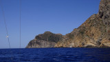
Capo Teulada is forms the southern tip of Sardinia. It is a rocky cliff, 223 m high, which ends at S a peninsula whose slope gradually at N and decreases to the low sandy isthmus that connects the coast. The entire Cape Teulada is, from the fifties, a military firing. Military ...
Cala Piombo is a large bay that lies between Punta della cala Piombo to Punta Aligusta. It is well sheltered to S and SE winds. It is lined by a small beach on the SE side.Better not anchor here with strong north-westerly wind (Mistral) because
it has the tendency to turn and come ...
This small cove called also Cala Brigantina, is located inside the shooting zone of Teulada cape where it is strictly to anchor.
Like Cala Piombo, here anchorage is allowed usually from 20th of June and the 20th of September. Strictly forbidden the rest of the year. Usually an ...
This tower is located on the high promontory of Punta della Torre, to E of Porto Zafferano. The tower of Porto Scudo is part of a system of coastal towers that were built by the Aragonese in the sixteenth century on the headlands of the coast of southern Sardinia to spot pirates.


 Cala d'Aligusta is between Teulada cape and d'Aligusta point, to W side of cape. It is inside the military polygon of Teulada cape.
 Cala d'Aligusta se trouve entre le cap Teulada et la pointe d'Aligusta, sur la côte W du cap. Elle est à l'intérieur du polygone militaire du cap Teulada.
 Cala D'Aligusta si trova tra il capo Teulada e la punta d'Alista, nella costa W dal capo. E' all'interno del poligono militare di Capo Teulada.
")