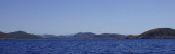
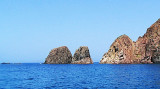
Capo Teulada is forms the southern tip of Sardinia. It is a rocky cliff, 223 m high, which ends at S a peninsula whose slope gradually at N and decreases to the low sandy isthmus that connects the coast. The entire Cape Teulada is, from the fifties, a military firing. Military activities are decreased over the years. The bays are formally within the areas closed to shipping which is actually tolerated in the summer months (from June 20 to September 21 exercises are suspended).
2012/10/3
Update
longroute
This is Capo Teulada seen from East (Teulada Marina)
2012-10-03
Update
longroute
Le cap Teulada forme l'extrémité méridionale de la Sardaigne. C'est une falaise rocheuse haute de 223 m qui termine au S une presqu'île dont la pente N s'abaisse graduellement jusqu'à l'isthme bas et sablonneux qui la relie à la côte L'ensemble du cap Teulada est, depuis les années 50, un polygone militaire. Les baies à l'intérieur de la zone militaire, sont formellement interdites à la navigation qui est tolérée pendant les mois d'été (du 20 juin au 20 septembre, période où les exercices sont suspendus).
2012/10/4
Update
Abu68
2012-10-24
Update
Joëlle
Capo Teulada è l'estremita sud-occidentale della Sardegna. E' Si tratta di una rupe rocciosa alta 223 m, che termina al S in una penisola la cui pendenza N diminuisce gradualmente al basso istmo sabbioso che lo collega alla costa.
L'intero Capo teulada è, dagli anni cinquanta un poligono militare. Le attività militari sono molto calate negli anni. Le baie all’interno dell’area sono formalmente zone vietate alla navigazione che in realtà è tollerata nei mesi estivi (dal 20 giugno al 21 settembre le esercitazioni sono sospese).
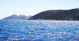
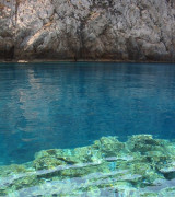
Cala d'Aligusta is between Teulada cape and d'Aligusta point, to W side of cape. It is inside the military polygon of Teulada cape. It is a very small cove, very open to W winds. The small pebble beach is full of fragments brought by the storms.La cala d'Aligastro has a cave that ...
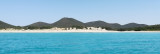
Cala Piombo is a large bay that lies between Punta della cala Piombo to Punta Aligusta. It is well sheltered to S and SE winds. It is lined by a small beach on the SE side.Better not anchor here with strong north-westerly wind (Mistral) because
it has the tendency to turn and come ...
This small cove called also Cala Brigantina, is located inside the shooting zone of Teulada cape where it is strictly to anchor.
Like Cala Piombo, here anchorage is allowed usually from 20th of June and the 20th of September. Strictly forbidden the rest of the year. Usually an ...
This tower is located on the high promontory of Punta della Torre, to E of Porto Zafferano. The tower of Porto Scudo is part of a system of coastal towers that were built by the Aragonese in the sixteenth century on the headlands of the coast of southern Sardinia to spot pirates.


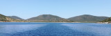
 Capo Teulada is forms the southern tip of Sardinia. It is a rocky cliff, 223 m high, which ends at S a peninsula whose slope gradually at N and decreases to the low sandy isthmus that connects the coast.
") This is Capo Teulada seen from East (Teulada Marina)
This is Capo Teulada seen from East (Teulada Marina) Le cap Teulada forme l'extrémité méridionale de la Sardaigne. C'est une falaise rocheuse haute de 223 m qui termine au S une presqu'île dont la pente N s'abaisse graduellement jusqu'à l'isthme bas et sablonneux qui la relie à la côte
")
 Capo Teulada è l'estremita sud-occidentale della Sardegna. E' Si tratta di una rupe rocciosa alta 223 m, che termina al S in una penisola la cui pendenza N diminuisce gradualmente al basso istmo sabbioso che lo collega alla costa.
") Cape viewed from the East.
Cape viewed from the East.