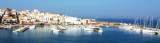
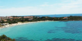
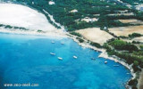
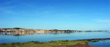
Punta Trettu is the tip, on the Sardinian mainland, which is NE of the lagoon of Sant'Antioco and that facing Dritta tip on the island of Sant'Antioco.
The tip is made of gravel and water and sandy bottoms are very low.
It is a Kitesurfing spot where the Mistral blows, but the sea is flat due to little background.
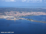
Sardinian coast is low and sandy, from Punta Trettu to Portovesme where you can see the à partir de Punta Trettu
jusqu'à Portovesme où l'on aperçoit les cheminées d'une centrale
électrique et les installations d'embarquement de charbon.
2012/11/3
Update
Bonjour,
Punta Trettu est un endroit kitesurf tres connu. Avec une toile de fond basse et eau basse, ce kite spot offres généralement des conditions parfaites tant pour les débutants tant pour les kiters avancés. Pour plus d'infos, cous pouvez visiter le site http://kitepuntatrettu.com/fr/
2017/11/17
Update
Punta Trettu est la pointe, sur le continent sarde, qui se trouve au NE de la lagune de Sant'Antioco et qui fait face à la pointe Dritta sur l'île de Sant'Antioco.
La pointe est formée de gravier et d'eau, et les fonds sablonneux sont très faibles.
C'est un spot de Kitesurf où le Mistral souffle, mais la mer est plate à cause du peu de fond.
La côte sarde est basse et sablonneuse, à partir de Punta Trettu
jusqu'à Portovesme où l'on aperçoit les cheminées d'une centrale
électrique et les installations d'embarquement de charbon.
2012/11/3
Update
Punta Trettu è la punta, sullo continente sardo, che è NE della laguna di Sant'Antioco e di fronte a punta Dritta sull'isola di Sant'Antioco.
La punta è fatta di ghiaia e acqua e i fondali sabbiosi sono molto basse.
Questo è un spot di kitesurf dove soffio il Mistral, ma il mare è piatto a causa di fondali molto bassi.
La costa di Sardegna è bassa e sabbiossa, da Punta Trettu a Portovesme dove si puo vedere i ciminiere di una centrale elettrica e le strutture per l'imbarco del carbone.
Between Punta Dritta (Sant Antioco) and Punta Trettu (on the sardinia mainland) is the canale dredged to 4 m, which leads to the small port of S. Antioco.
Many shoals obstruct the channel and allow passage to vessels with a draugh of less than 4 m.S part of the channel is deep ...
Calasetta commercial port, with low depth, is E of the marina. Visitors can accost at the "B" quay, in 4 m.Beware secca del Francese (2,9 m) N harbour, marked by a N cardinal mark. T. 88930 2 b. visit. (<16 m)Calasetta marina:Outside the commercial port, to W is the Calasetta ...
Ponte Romano harbour is the commercial port of Sant'Antioco.It is reached by the S (Gulf of Palmas) with a marked navigable channel which leads to a lateral basin evolution protected by rocks and a large pier.Pleasure boats can approach the inner pair of buoys, allowing free passage. ...
After the tip delle Saline is a pond behind the beach, and Delle Saline beach continues to expand with sand dunes covered with abundant vegetation that separates the pond.
This cove is popular with windsurfers who take advantage of the wind blowing offshore.


")
")
 Punta Trettu is the tip, on the Sardinian mainland, which is NE of the lagoon of Sant'Antioco and that facing Dritta tip on the island of Sant'Antioco.
 Punta Trettu est la pointe, sur le continent sarde, qui se trouve au NE de la lagune de Sant'Antioco et qui fait face à la pointe Dritta sur l'île de Sant'Antioco.
 Punta Trettu è la punta, sullo continente sardo, che è NE della laguna di Sant'Antioco e di fronte a punta Dritta sull'isola di Sant'Antioco.