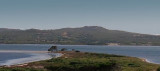
Between Punta Dritta (Sant Antioco) and Punta Trettu (on the sardinia mainland) is the canale dredged to 4 m, which leads to the small port of S. Antioco.
Many shoals obstruct the channel and allow passage to vessels with a draugh of less than 4 m.
S part of the channel is deep and clear. The safest route is through the central part of the way. It is marked by buoys are moored in the vicinity of Carloforte (1 MN).
Just E of the buoy a shoal extends to a minimum depth of 5 m. Caution should be exercised and navigate cautiously in this area.
N, several shoals extend with large areas of water between them and the shore.
2012/11/3
Update
2012-11-03
Update
Entre la pointe Dritta (Sant Antioco) et la pointe Trettu (sur le continent sarde) passe le chenal dragué à 4 m qui conduit au petit port de S. Antioco.
De nombreux hauts-fonds obstruent le canal et ne permettent le passage qu'aux bateaux ayant un TE de moins de 4 m.
La partie S du chenal est profonde et claire. La route la plus sûre se trouve à travers la partie central du passage. Elle est balisée par des bouées qui sont amarrées dans le voisinage de Carloforte (à 1 MN).
Juste à l'E de ces bouées un haut-fond s'étend à une profondeur minimale de 5 m. Il faut être prudent et naviguer prudemment dans cette zone.
Au N, plusieurs hauts-fonds s'étendent avec de vastes zones d'eau entre eux et le rivage.
2012/11/3
Update
Tra punta Dritta (Sant Antioco) e punta Trettu (continente di Sardegna) passa il canale dragato a 4 m, che conduce al porto di S. Antioco.
Molti banchi ostacolano il canale e permettono il passaggio di navi di pescaggio inferiore a 4 m.
S parte del canale è profondo e chiaro. La via più sicura è attraverso la parte centrale del passaggio. E 'caratterizzato da boe che sono ormeggiate in prossimità di Carloforte (1 MN).
Proprio E della boa una secca si estende per una profondità minima di 5 m. Si deve usare con cautela e navigare con prudenza in questa zona.
N, banchi diversi si estendono con ampie zone di acqua tra loro e la riva.
Punta Trettu is the tip, on the Sardinian mainland, which is NE of the lagoon of Sant'Antioco and that facing Dritta tip on the island of Sant'Antioco.
The tip is made of gravel and water and sandy bottoms are very low.
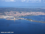
Calasetta commercial port, with low depth, is E of the marina. Visitors can accost at the "B" quay, in 4 m.Beware secca del Francese (2,9 m) N harbour, marked by a N cardinal mark. T. 88930 2 b. visit. (<16 m)Calasetta marina:Outside the commercial port, to W is the Calasetta ...
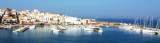
Ponte Romano harbour is the commercial port of Sant'Antioco.It is reached by the S (Gulf of Palmas) with a marked navigable channel which leads to a lateral basin evolution protected by rocks and a large pier.Pleasure boats can approach the inner pair of buoys, allowing free passage. ...
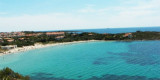
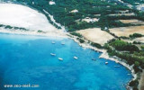
After the tip delle Saline is a pond behind the beach, and Delle Saline beach continues to expand with sand dunes covered with abundant vegetation that separates the pond.
This cove is popular with windsurfers who take advantage of the wind blowing offshore.


 Between Punta Dritta (Sant Antioco) and Punta Trettu (on the sardinia mainland) is the canale dredged to 4 m, which leads to the small port of S. Antioco.
")
 Entre la pointe Dritta (Sant Antioco) et la pointe Trettu (sur le continent sarde) passe le chenal dragué à 4 m qui conduit au petit port de S. Antioco.
 Tra punta Dritta (Sant Antioco) e punta Trettu (continente di Sardegna) passa il canale dragato a 4 m, che conduce al porto di S. Antioco.