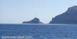
Cala del Faro, a cove where are facilities of the NATO radar base, lies on the S of Punta Timone. Here there is a ban on navigation is less than 500 meters from the coast, for reasons of military security.
2012/10/3
Update
Joëlle
La cala Del Faro, anse profonde, où est installée la base du radar NATO, se trouve au S de Punta Timone. Ici il est interdit de naviguer à moins de 500 m de la côte, pour raison de sécurité militaire.
2012/10/3
Update
Joëlle
La cala del Faro, profonda insenatura, con le installazioni della base radar
NATO, è S da Punta Timone. Qui vige un divieto di navigazione a meno di 500 metri dalla costa,
per motivi di sicurezza militare.
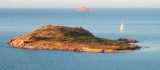
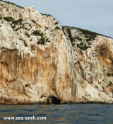
Tavolara island is a limestone massif 6 kilometres long and 500 m wide, and 565 m high.The overhanging cliffs make it inaccessible, with the exception of a bay and a beach that is located at each end of the island, Spalmatore di Fuori northeast (military zone) and Spalmatore di Terra ...
Degli Aranci gulf is is bounded, on the N, by the peninsula of which Capo Figari is the E extremity.This gulf is sheltered from NE and NW winds. Strong SE winds send in a heavy sea and storms from the N and E cause a considerable swell in the gulf. During offshore winds, which are ...
Isola Molara, private island, S Tavolara island, 158m high, is undulating and partially cultivated.The coasts are high and rocky at E (Punta Levante et Punta di Sirocco), they are more practicable with the few beaches and coves located in NW (Cala Cala Chiesa e Spagnola).We see a ...
The lighthouse of Punta Timone at the NE end of the island, is a white octagonal tower 7 m high. Its range is 15 NM. It is also equipped with a lantern reserve with a minimum range of 12 NM.
Tavolara Island had a strategic importance in 1861. Merchant Navy built
with the cooperation of the prisoners on the island at the time, at
Spalmatore di Fuori, a lighthouse of 2 floors.
The lighthouse was
built on the mountain falls steeply to the sea and it was therefore ...


 Cala del Faro, a cove where are facilities of the NATO radar base, lies on the S of Punta Timone. Here there is a ban on navigation is less than 500 meters from the coast, for reasons of military security.
 La cala Del Faro, anse profonde, où est installée la base du radar NATO, se trouve au S de Punta Timone. Ici il est interdit de naviguer à moins de 500 m de la côte, pour raison de sécurité militaire.
 La cala del Faro, profonda insenatura, con le installazioni della base radar
NATO, è S da Punta Timone. Qui vige un divieto di navigazione a meno di 500 metri dalla costa,
per motivi di sicurezza militare.
La cala del Faro, profonda insenatura, con le installazioni della base radar
NATO, è S da Punta Timone. Qui vige un divieto di navigazione a meno di 500 metri dalla costa,
per motivi di sicurezza militare.