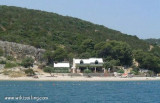
Starogradski Zaljev Hvar
12nm
220°
There are several bays, including its N side, where it is possible to anchor. On the other side there is an anchor in front Gradisce.
31 May 11
Jojo
| Latitude | Longitude | |
| DMS | --- | --- |
| DM | --- | --- |
| DD | --- | --- |

 quais N et S
 quais N et S


")
")
")
Ebook | Splitsko-dalmatinska županija (Split-Dalmatia Coun
|
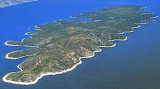
 Pucisca is the port and the largest city on the N side of Brac. It is a place known for a tradition of stone masons, and stone of Brac has been used for the construction of the White House in Washington among others.
 Pucisca est le port et la plus grande agglomération sur la côté N de Brac. C`est un lieu connu par une tradition des tailleurs de pierres, et la pierre de Brac a servi pour la construction de la Maison Blanche à Washington entre autres.
Ebook | Dalmacija (Dalmatie)
|