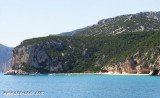
Magnifique plage de sable fin, dans la baie de l'Alicastre, où il est agréable de se baigner dans une eau claire couleur turquoise. Abritée par vent d'E, à éviter par Mistral. Autorisée à tous les bateaux en dehors des bouées de la plage de Notre-Dame.
Les bateaux à moteur sont interdits dans la zone des 300m.
Quartu gulf lies between Foxi tower and S. Elia cape, in the Cagliari Gulf.It is not recommended to anchor in the Quartu bay.Ancorage is also prohibited in a strip between the bearings to 314 ° of Mezza Spiaggia tower and 316 ° to the S. Elia E end cape and extending to 7 NM of shore.
Gulf di Tortoli is entered between Isola dell’Ogliastra and Capo Bellavista, marked by a light, 2.5 miles S. Winds from the NW and NE quadrants come up suddenly and blow with extreme violence in this vicinity. They may last for 4 or 5 days and are preceded by whitish clouds ...
Beautiful sandy beach Beautiful sandy beach where you can anchor in 5 meters of water. At the bottom there are characteristic caves.Sheltered of W wind and very open to the E.
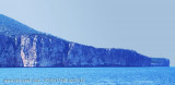
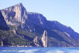
Cape Monte Santu (Monte Santo) is a rocky massif that separates Tortoli of Orosei. It rises perpendicularly from the sea.
Nearby is the Grotta dei Colombi accessible by sea. In these waters is also the wreck of a cargo 50s. The coast between Capo di Monte Santu and Capo ...
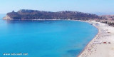
Cala Gonone, located 7.5 miles SW of Punta Nera, can be easily recognized by a group of houses which stand on the shore and interrupt the uninhabited appearance of this part of the coast. Villa Maria Luisa, light blue with yellow shutters, is the most conspicuous building in this ...


") a
a") Belle plage et eau claire.
Belle plage et eau claire. Magnifique plage de sable fin, dans la baie de l'Alicastre, où il est agréable de se baigner dans une eau claire couleur turquoise.
")
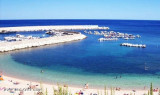
") Mouillage toujours très prisé.
Mouillage toujours très prisé.")