Otok Susac Lastovo

Otok Susac Lastovo

To precisely geolocate this site. Update if necessary.

Localisation

Characteristics

Island / Atoll
Lighthouse
Natural Park

Description

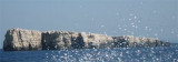
Otok Susac rises to heights of 82m in the SW part and 239m in the NE part. From a distance, this island appears as two islets. Its sides are partly wooded, cliffy, and steep-to.

The eastern part is shallow and ideal for swimming. The southern part and the part of south-west are steep with many rocks.

It is 13 NM from O. Lastovo.

A light is shown from a conspicuous structure, 20m high, standing on Rt Triscavac, the SW extremity of the island.

It is inhabited by the family of the lighthouse keeper and a shepherd.

2011/05/11
Update
Jojo
Otok Susac Lastovo
Otok Susac
2011-05-11
Update
Jojo
Otok Susac s'élève à  82m dans la partie sud-ouest et 239 m dans la partie nord. De loin, cette île apparaît comme deux îlots. Ses côtes sont en partie boisées, escarpées, raides et accores.

La partie orientale est peu profonde et idéale pour se baigner. La partie méridionale et la partie du sud-ouest sont escarpées avec des nombreux rochers.

Elle se trouve à 13 NM à l'W de O. Lastovo.

Un phare est représenté par une structure remarquable, de 20 mètres de haut, sur ​​Rt Triscavac, l'extrémité sud-ouest de l'île.

Elle est habitée par la famille du gardien du phare et un berger.

2011/05/11
Update
Jojo
Ebook

Dubrovačko-neretvanska županija (Dubrovnik–Neretva

  • 138 sites
  • 228 photos
  • publication date: 9 Jul 2023
  • .pdf file size: 74 Mb
Otok Susac Lastovo
Susac Light house
Maurizio
28th July 2012
2017-07-03
Update
Anonymous
Share your comments or photos on "Otok Susac Lastovo"

Sites around Otok Susac Lastovo

Flying distances - Direct line

Starogradski Zaljev Hvar

26nm
Starogradski is a large deep bay, open to the NW, which houses the city and the port of Stari Grad on its SE end.
There are several bays, including its N side, where it is possible to anchor. On the other side there is an anchor in front Gradisce.
31 May 11
Jojo

Uvala Vela Luka Korcula

13nm
31°
Zaljev Vela Luka is a large bay on the E O. Korcula. Many coves occupy the bay. At the bottom of it is the port of Vela Luka, an active and well sheltered.
Easily identifiable by day or night, you can enter this great bay in all weather.
Dangers in the general approach are the ...
21 May 11
Jojo

Otoci Pakleni

24nm
346°
Plakeni islands, or Cursed Islands, are located at the W and S of Hvar town.

The islands are rocky, covered with bushes and trees. They are usually deserted, except in summer.
They offer many choices of moorings sheltered and there is a marina Palmizana.The islands'name ...
26 May 11
Jojo

Otok Kopiste Lastovo

8.8nm
92°
L'île Kopiste appartient au groupe d'îles du parc naturel de Lastovo. Elle est située à l'W de Lastovo après O. Przba et O. Mrcara dont elle est séparée par le canal de Zaplja.
Elle est entourée de trois îlots: O. Bijelac, O. Pod Kopiste et O Crnac.
11 May 11
Jojo

Otok Svetac (Andrija)

36nm
295°
Otok Svetac (Andrija), 305m high, lies 13 miles ESE of Otocic Jabuka and is generally steep-to. The coast of the island is rocky and reddish in color on the NW side. Its SW end is fronted by a few rocks. Hrid Kamik, a dark and jagged above-water rock, lies 0.7 mile W of the SW extremity ...
25 May 11
Jojo

Pakleni Kanal

25nm
347°
Pakleni Kanal lies between Pakleni Otoci and Otok Hvar.
It is a deep and wide channel, with access at both ends, which leads to Luka Hvar.
This channel is frequented by small vessels with local knowledge and affords good shelter from the bora, although heavy squalls may be encountered.
The ...
30 May 11
Jojo