Otok Svetac (Andrija)

Otok Svetac (Andrija)

To precisely geolocate this site. Update if necessary.

Localisation

Characteristics

Island / Atoll

Description

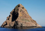
Otok Svetac (Andrija), 305m high, lies 13 miles ESE of Otocic Jabuka and is generally steep-to. The coast of the island is rocky and reddish in color on the NW side. Its SW end is fronted by a few rocks. Hrid Kamik, a dark and jagged above-water rock, lies 0.7 mile W of the SW extremity of the island.
Otocic Brusnik, dark and surrounded by rocks and reefs, lies 1.7 miles SE of Otok Svetac and should not be closely approached.
A rocky shoal, with a depth of 7m, lies about 0.2 mile N of this islet.
2011/05/25
Update
Jojo
Otok Svetac (Andrija)
Otok Svetac
2011-05-25
Update
Jojo
Otok Svetac (Andrija), haute de 305 m, se trouve à 13 miles à l'ESE de Otocic Jabuka et est généralement accore.
La côte de l'île est rocheuse et de couleur rougeâtre sur le côté nord-ouest. Son extrémité sud-ouest est bordée par quelques rochers.
Hrid Kamnik, un rock sombre et dentelé au-dessus de l'eau, se trouve à 0.7 mile à l'W de l'extrémité sud-ouest de l'île.
Otocic Brusnik, sombre et entourée de rochers et de récifs, se trouve à 1.7 miles au SE de Otok Svetac et ne doit pas être approchée.
Un haut-fond rocheux, sous 7m d'eau, se trouve à environ 0,2 mile au N de cet îlot.
2011/05/25
Update
Jojo
Otok Svetac (Andrija)
Hrid Kamnik
2011-05-25
Update
Jojo
Otok Svetac (Andrija)
Otocic Brusnik
2011-05-25
Update
Jojo
Ebook

Splitsko-dalmatinska županija (Split-Dalmatia Coun

  • 155 sites
  • 295 photos
  • publication date: 6 Jul 2023
  • .pdf file size: 97 Mb
Share your comments or photos on "Otok Svetac (Andrija)"

Sites around Otok Svetac (Andrija)

Flying distances - Direct line

Otok Zirje (Sibenik)

37nm
354°
Otok Zirje is the farthest and the largest island in the Sibenik archipelago.
It is long of 6,5 NM (NW/SE) and 1,4 NM wide.
The main village, Zirje, is located in the middle of the island. A small port, luka Muna, on the coast N of Zirje, home to the ferry that connects the ...
16 Aug 11
Croatia

Otok Bisevo

11nm
107°
Bisevo is located SW of Vis, 4 NM Komiza. This small inhabited island has an area of 5.8 sq. km. The highest point is Strazenica (239 m). The islanders live from fishing and agriculture.
On its shores steep, there are many caves, the most famous is the Blue Cave (18 m long, 6 m ...
24 May 11
Jojo

Bisevski Kanal

13nm
98°
Bisevski Kanal, 2.2 miles wide, leads between Otok Bisevo and Otok Vis. This channel, in good weather, can be used to advantage to shorten the route out of the Adriatic. However, in winter with strong winds and currents it is best avoided.
24 May 11
Jojo

Otoci Pakleni

28nm
73°
Plakeni islands, or Cursed Islands, are located at the W and S of Hvar town.

The islands are rocky, covered with bushes and trees. They are usually deserted, except in summer.
They offer many choices of moorings sheltered and there is a marina Palmizana.The islands'name ...
26 May 11
Jojo

Otocic Jabuka

13nm
281°
Otocic Jabuka, 96m high, lies nearly in the middle of the Adriatic about 50 miles WSW of Split and 15 NM of O. Svetac.
This rock is barren, reddish-colored, and steep-to. Whenviewed from the SW or NE, it appears as a vessel under sail.Plicina Jabuka, an isolated rocky patch, lies ...
25 May 11
Jojo

Otok Murter

46nm
352°
The island of Murter is the largest island of the Sibenik archipelago. It is close to the coast on which it is connected by a bridge, low air draft at Tijesno (Tisno) on the continent. During the summer the bridge opens to allow passage of boats.
The NW part of the island is fertile ...
3 Apr 11
Jojo