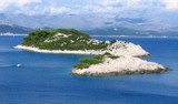
Otocic Daksa , a densely-wooded island, lies with its S extremity located 0.3 mile N of Rt Gnjiliste. Its summit is surmounted by a ruined fort. A light is shown from a structure, 4m high, standing near the shore on the N extremity of the island. A prominent disused light structure stands above the light.
2011/04/15
Update
Jojo
Otocic Daksa, une île densément boisée, se trouve à son extrémité S, située 0.3 M au N de Rt Gnjiliste. Son sommet est surmonté par un fort en ruines. Le feu est représenté par une structure, haute de 4m, près de la rive à l'extrémité N de l'île. Une structure légère,ancien feu, désaffectée surmonte le feu.
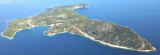
It is the largest and most populated island of the group Elafiten. It rises to 234 m at its N and a prominent hill rises 224 m NW of the SE end. Ruda is a small island that is 0.5 M SE of the NE extremity of the island and Misnjaka, 13 m high, lies close off the NW extremity. ...
The island of Lopud belongs Elaphites. It is only 4.6 km2. It has a pleasant village and some old buildings. You'll find a sandy beach. There are two good anchorages: uvala Lopud (NW of the island), where is the village and uvala Sunj (SE of the island).
Zupski Zaliv is entered between Rt Sustjepan and Rt Pelegrin, 2.5 miles NW. The E and SE shores of this bay are backed by mountains, but a valley through which a river flows lies within the N shore. Malastica, 628m high, stands 1 mile N of the bay. This hill has a somewhat sharp ...
Kolocep island is located two NM from Dubrovnik. This small island is part of the archipelago of islands Elafiten. Locals also call it Kalamota. Its area is 2.35 km2. On the island there are two villages in the two largest bays of the island: Gornje Celo and Donje Celo that ...
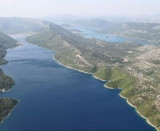
Stonski Kanal, a deep inlet, indents the SE end of Poluotok Peljesac at the NW end of Kolocepski Kanal. Its shore rises rapidly on each side and provides protection from NE and SW winds. The village of Brocej is situated on the S shore 3.8 miles within the entrance. It is fronted ...
Hridi Grebeni consists of a chain of barren, jagged, and reddish above-water rocks that lie on a reef between 0.2 and 0.6 mile W of Rt Petka. A passage leads between these rocks and the point, but it is only used by small vessels with local knowledge. A light is shown from a ...


 Otocic Daksa , a densely-wooded island, lies with its S extremity located 0.3 mile N of Rt Gnjiliste.
 Otocic Daksa, une île densément boisée, se trouve à son extrémité S, située 0.3 M au N de Rt Gnjiliste.