Otok Sveti Klement Pakleni

Otok Sveti Klement Pakleni

To precisely geolocate this site. Update if necessary.

Localisation

Characteristics

Island / Atoll

Description

The island Sveti Klement is the largest of the "Pakleni Otoci".
Its area is 5.27 square kilometers and it has 29.891 km of rocky coasts.
A portion of the island, whose highest peak, Glavica, is 94 m high, is covered with scrub and pine woods.
The island is surrounded by numerous rocks and shoals that need special attention.
Marina ACI Palmizana welcomes sailors whose vessels are less than 12 m long.
This island offers numerous bays boaters.
2011/05/27
Update
Jojo
L'île Sveti Klement est la plus grande des îles de l'archipel Pakleni.
Sa superficie est de 5,27 km² et elle a 29,891 km de côtes rocheuses.
Une partie de l'île, dont le plus haut sommet, Glavica, fait 94 m de haut, est recouverte de maquis et de bois de pins.

L'île est entourée de nombreux rochers et hauts-fonds auxquels il faut accorder une attention particulière.

La marina ACI de Palmizana accueille les plaisanciers dont les bateaux sont inférieurs à 12 m de long.

Cette île offre de nombreuses baies aux plaisanciers.

2011/05/27
Update
Jojo
Ebook

Splitsko-dalmatinska županija (Split-Dalmatia Coun

  • 155 sites
  • 295 photos
  • publication date: 6 Jul 2023
  • .pdf file size: 97 Mb
Otok Sveti Klement Pakleni
2011-05-27
Update
Jojo
Share your comments or photos on "Otok Sveti Klement Pakleni"

Sites around Otok Sveti Klement Pakleni

Flying distances - Direct line

Otoci Pakleni

0.9nm
83°
Plakeni islands, or Cursed Islands, are located at the W and S of Hvar town.

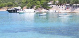
The islands are rocky, covered with bushes and trees. They are usually deserted, except in summer.
They offer many choices of moorings sheltered and there is a marina Palmizana.The islands'name ...
26 May 11
Jojo

Pakleni Kanal

1.4nm
49°
Pakleni Kanal lies between Pakleni Otoci and Otok Hvar.
It is a deep and wide channel, with access at both ends, which leads to Luka Hvar.
This channel is frequented by small vessels with local knowledge and affords good shelter from the bora, although heavy squalls may be encountered.
The ...
30 May 11
Jojo

Otok Ciovo

20nm
352°
Ciovo is an island in the center of the Dalmatian archipelago. This is an area of 28.8 acres (15.3 km length, width of 3.5 km). It culminates at 218 m (Mount Rudin).
O. Ciovo forms the SW side of the entrance and inner part of Kastelanski Zaliv.
At East side, Ciovo is 2km from ...
7 Aug 11
cdg2

Starogradski Zaljev Hvar

8.7nm
76°
Starogradski is a large deep bay, open to the NW, which houses the city and the port of Stari Grad on its SE end.
There are several bays, including its N side, where it is possible to anchor. On the other side there is an anchor in front Gradisce.
31 May 11
Jojo

Otok Svetac (Andrija)

27nm
253°
Otok Svetac (Andrija), 305m high, lies 13 miles ESE of Otocic Jabuka and is generally steep-to. The coast of the island is rocky and reddish in color on the NW side. Its SW end is fronted by a few rocks. Hrid Kamik, a dark and jagged above-water rock, lies 0.7 mile W of the SW extremity ...
25 May 11
Jojo

Luka Soline- Sveti Klement- Pakleni

0.4nm
109°
This large bay is located almost in the middle of the coast S of O. Sveti Klement, facing O. Dobri that protects winds S.
The best anchorage is in Part E of the bay by 2 to 8 m.
Attention to the submarine cable coming ashore on the NW side.
Exposed to SW.
27 May 11
Jojo