Olbia porto interno (Sardegna)

Olbia porto interno (Sardegna)

To precisely geolocate this site. Update if necessary.

Localisation

Olbia porto interno (Sardegna)
LatitudeLongitude
DMS------
DM------
DD------

Characteristics

Port
Grass
Rock
Mud
Mooring
VHF canal 11, 16
Water
Phone
Electricity
Fuel
Shipyard
Slip
Restaurant

Description

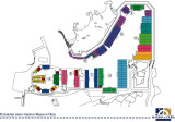
Once in the Gulf of Olbia, it can be difficult to identify the channel until the lighthouse (square white tower on two floor building) is identified. Once in the channel approach is straight remaining cautious in the final approach to the S side of the long pier central.

The current is not important, it is almost nonexistent in the port. Outside the port it can reach 3 or 4 knots.

Totally contrasting with the wonders of N, Olbia is a bustling little town, a bit dingy.

Danger: Torracia shoal (0.8 m) at the entrance of the port.

Upon arrival to get in touch with the captaincy.

  • 250 pl (<16 m)
  • Draugh: 2.5 to 6 m
  • T. 078926187
  • M. circolonauticoolbia@tin.it

Beware: prohibition cluttering the access channel at pier Olbia maritima and its surroundings. Ferries have priority. Arrived early morning and late evening.

2012/09/30
Update
Joëlle
Olbia porto interno (Sardegna)
2012-09-30
Update
Joëlle
Une fois dans le golfe d'olbia, il peut être difficile de repérer le chenal jusqu'à ce que le phare (tour carrée blanche sur bâtiment à deux étages) soit identifié. Une fois dans le chenal l'approche est franche en restant prudent dans l'approche finale du côté S du long môle central.

Le courant n'est pas important, il est presque inexistant dans le port. A l'extérieur du port il peut atteindre 3 ou 4 nœuds.

Contrastant totalement avec les merveilles du N, Olbia est une petite ville animée, un peu crasseuse.

Danger: le haut-fond Torracia (0,8 m) à l'entrée du port.

A l'arrivée se mettre en contact avec la capitainerie.
  • 250 pl (<16 m)
  • TE: 2,5 à 6 m
  • T. 078926187
  • M. circolonauticoolbia@tin.it

Attention, interdiction d'encombrer le chenal d’accès au môle Olbia maritima et ses abords. Les ferries sont prioritaires. Arrivées début de matinée et fin de soirée.
2012/09/30
Update
Joëlle
Olbia porto interno (Sardegna)
2012-09-30
Update
Joëlle
Una volta nel Golfo di Olbia, può essere difficile individuare il canale fino al faro (torre quadrata  bianca su edificio a due piani), è identificato. Una volta entrati nel canale l'approccio è semplice rimanere prudente nell'approccio finale sul lato S del lungo molo centrale.

La corrente non è importante, è quasi inesistente nel porto. Fuori dello porto può raggiungere i 3 o 4 nodi.

Totalmente in contrasto con le meraviglie di N, Olbia è una piccola città vivace, un po 'squallide.

Pericolo: secca Torracia (​​0,8 m) all'ingresso del porto.

All'arrivo di entrare in contatto con la fascia di capitano.

  • 250 pb (<16 m)
  • Fondali: 2.5 to 6 m
  • T. 078926187
  • M. circolonauticoolbia@tin.it

Attenzione: divieto ingombrare il canale di accesso al molo maritima di Olbia e dintorni. I traghetti sono una priorità. Sonno arrivati ​​la mattina presto e la sera tardi.

2012/09/30
Update
Joëlle
Olbia porto interno (Sardegna)
2012-09-30
Update
Joëlle
Ebook

Sardegna North East

  • 156 sites
  • 349 photos
  • publication date: 11 Jul 2023
  • .pdf file size: 66 Mb
Ebook

Sardegna

  • 444 sites
  • 1069 photos
  • publication date: 11 Jul 2023
  • .pdf file size: 243 Mb
Share your comments or photos on "Olbia porto interno (Sardegna)"

Sites around Olbia porto interno (Sardegna)

Flying distances - Direct line

Isola Tavolara (Sardegna)

8.4nm
96°
Tavolara island is a limestone massif 6 kilometres long and 500 m wide, and 565 m high.The overhanging cliffs make it inaccessible, with the exception of a bay and a beach that is located at each end of the island, Spalmatore di Fuori northeast (military zone) and Spalmatore di Terra ...
7 May 14
Joëlle

Golfo degli Aranci (Sardegna)

5.8nm
50°
Degli Aranci gulf is is bounded, on the N, by the peninsula of which Capo Figari is the E extremity.This gulf is sheltered from NE and NW winds. Strong SE winds send in a heavy sea and storms from the N and E cause a considerable swell in the gulf. During offshore winds, which are ...
28 Sep 12
Joëlle

Golfo Di Arzachena (Sardegna)

12nm
345°
Gulf of Arzachena (Arsachena), located between Punta Saline and Tre Monti Cape, is a high inlet whose banks are lined with shoals.
S tip, Arzachena, W of the entrance, a beacon consists of an iron post with a sheer spherical white marks a rock particularly ...
8 Sep 12
Joëlle

Isola La Maddalena (Arcipelago della Maddalena)

19nm
344°
It is the largest island of the archipelago composed of sixty islets and 7 major islands, in the NE end tip of Sardinia. It is mountainous and arid. This is the only inhabited island thoroughly.
It is connected by a bridge to Caprera island where are the house and the tomb of Garibaldi. ...
26 Nov 12
Joëlle

Golfo di Marinella (Sardegna)

6nm
20°
This gulf is S Cugnana gulf, S cala della Volpe. It is entered between Punta della Volpe and Punta Canigione.This gulf is the most protected area of the coast. Although the anchorage is prohibited in the Gulf because of submarine telegraph cables, many boaters anchor in this ...
23 Sep 12
Joëlle

Marina di Olbia

0.4nm
175°
This marina, created in may 2009, is SW of gulf. The management of it is under the responsability af "Marina di Olbia Yachting Services".270 b (<60 m)Depth: 3 to 5 m
tel. +39 0789 67121
fax +39 0789 645842M. info@marinadiolbia.it
30 Sep 12
Joëlle