Tavolara island is a limestone massif 6 kilometres long and 500 m wide, and 565 m high.The overhanging cliffs make it inaccessible, with the exception of a bay and a beach that is located at each end of the island, Spalmatore di Fuori northeast (military zone) and Spalmatore di Terra ...
Degli Aranci gulf is is bounded, on the N, by the peninsula of which Capo Figari is the E extremity.This gulf is sheltered from NE and NW winds. Strong SE winds send in a heavy sea and storms from the N and E cause a considerable swell in the gulf. During offshore winds, which are ...
Gulf of Arzachena (Arsachena), located between Punta Saline and Tre Monti Cape, is a high inlet whose banks are lined with shoals. S tip, Arzachena, W of the entrance, a beacon consists of an iron post with a sheer spherical white marks a rock particularly ...
It is the largest island of the archipelago composed of sixty islets and 7 major islands, in the NE end tip of Sardinia. It is mountainous and arid. This is the only inhabited island thoroughly. It is connected by a bridge to Caprera island where are the house and the tomb of Garibaldi. ...
This gulf is S Cugnana gulf, S cala della Volpe. It is entered between Punta della Volpe and Punta Canigione.This gulf is the most protected area of the coast. Although the anchorage is prohibited in the Gulf because of submarine telegraph cables, many boaters anchor in this ...
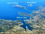
Once in the Gulf of Olbia, it can be difficult to identify the channel until the lighthouse (square white tower on two floor building) is identified. Once in the channel approach is straight remaining cautious in the final approach to the S side of the long pier central.


 This marina, created in may 2009, is SW of gulf. The management of it is under the responsability af "Marina di Olbia Yachting Services".
 Cette marina, créée en mai 2009, se trouve au SW du golfe. La gestion de celle-ci est faite par "Marina di Olbia Yachting Services".
 Questa marina, creata nel maggio 2009, si trova nel sud-ovest del Golfo. Di gestione è fatta da "Marina di Olbia Yachting Services".