New Ground Shoal (Florida)

New Ground Shoal (Florida)

To precisely geolocate this site. Update if necessary.

Localisation

New Ground Shoal (Florida)
LatitudeLongitude
DMS------
DM------
DD------

Characteristics

Description

New Ground, a shoal with a least depth of 4 feet at its W end, is about 6 miles long. It extends in an E-W direction about 3.5 miles N of The Quicksands.
A light is on the W side of the 4-foot spot. The water shoals abruptly on the N side of New Ground, and vessels should stay in depths greater than 13 fathoms to ensure clearing the shoal.

Between New Ground and The Quicksands is a natural channel about 2 miles wide with depths greater than 30 feet. The route should be used with caution because of the general irregularity of the bottom inside the 10-fathom curve.

A channel, sometimes used, lies W of Halfmoon Shoal, but is not recommended. SW of Halfmoon Shoal depths of 20 to 22 feet rise abruptly from depths of about 40 feet.

2012/04/8
Update
Cham
New Ground, un banc avec une profondeur minimum de 1,2 m à son extrémité W, est long d'environ 6 M. Il s'étend dans une direction E/W sur 3,5 M au N de Quicksands.
Un feu se trouve sur le côté W du point situé à 1,2 m. L'eau reonte soudainement sur le côté N de New Ground et les vaisseaux doivent rester dans les profondeurs plus grandes que 23,79 m par mesure de sécurité.

Entre New Ground et les Quiksands un chenal naturel s'étend, avec 2 M de largeur et une profondeur allant jusqu'à 9 m. Il faut prendre ce passage avec prudence à cause de l'irrégularité générale des fonds souvent inférieurs à 20 m.

Un chenal utilisé quelquefois, rejoint le côté W de Halfmoon Shoal, mais il n'est pas recommandé. Le SW d'Halfmoon Shoal a une profondeur de 6 à 6,6 m et remonte brusquement à environ 12 m.

2012/04/8
Update
Cham
Ebook

Gulf of Mexico

  • 227 sites
  • 182 photos
  • publication date: 9 Jul 2023
  • .pdf file size: 78 Mb
Share your comments or photos on "New Ground Shoal (Florida)"

Sites around New Ground Shoal (Florida)

Flying distances - Direct line

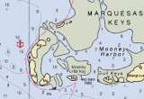
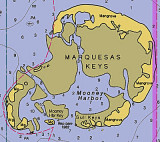
Marquesas Keys (Florida)

15nm
113°
The Marquesas Keys (not to be confused with the Marquesas Islands (French Polynesia in the Pacific Ocean) form an uninhabited island group about 30 miles (50 km) west of Key West, 4 miles (6 km) in diameter, and overgrown by mangrove. They are protected as part of the Key ...
8 Apr 12
Cham

Halfmoon Shoal (Florida)

7.9nm
216°
Halfmoon Shoal, covered 8 feet, is off the W end of The Quicksands. A wreck covered 6 feet and marked by a light is on the W edge of the shoal.
8 Apr 12
Cham

Rebecca Shoal (Florida)

12nm
242°
 Rebecca Shoal, 43 miles W of Key West, is a small coral bank covered 11 feet. Rebecca Shoal Light (24°34'42"N., 82°35'06"W.), 66 feet above the water, is shown from a square skeleton tower on a brown pile foundation on the S edge of the shoal. A red sector ...
8 Apr 12
Cham

Mooney Harbor SW anchorage (Florida)

13nm
118°
Mooney Harbor Key is located only about nine miles from Boca Grand. After carefully picking your way around the island you'll find a great outside anchorage on the west side of the island. This anchorage, with water depths of around 10 feet almost to the shore can be found at 24°33.826'N ...
8 Apr 12
Cham

The Quicksands (Florida)

15nm
231°
A large shoal, the W part of which is known as The Quicksands, extends 18 miles W from the Marquesas
Keys.
The shoal is about 4.5 miles wide between the 18-foot curves and has a least depth of 2 feet over its E part.
A strong E to W current is observed in the area of The Quicksands.
8 Apr 12
Cham

Pulaski Shoal (Dry Tortugas) (Florida)

20nm
272°
Pulaski Shoal, at the NE end of the group, is 12 miles NW of Rebecca Shoal. Pulaski Shoal Light (24°41'36.0"N., 82°46'22.7"W.), 56 feet above the water, is shown from a small black house on a hexagonal pyramidal skeleton tower on piles on the E side of the shoal.The keys are low ...
8 Apr 12
Cham