This marina is the most important of all the Smeralda coast. It is in a a wide cove accessible by a narrow channel. Porto Cervo with a luxury marina, like a " Saint Tropez" in Sardinia, home the most beautiful yachts in the Mediterranean. Port expensive.
The port is divided into two parts: the marina and the old port W E for boats in transit.
Danger:1M SE of Cape Ferro, red and white buoy of the shoal del Cervo (shoal covered 2.30 m of water).
T. 90 514
F. 91 153
M. www.pcmarina.it
700b. incl. 70 visit. (<90 m)
Report to the harbour master to assigning a place.
Entering on the right is a reserved area at anchor. Beware shoals insulated at W of anchorage area, visible only in calm seas.
2012/09/12
Update
Joëlle
2012-09-12
Update
Joëlle
Ce port de plaisance est le plus important de toute la Costa Smeralda. Il a été aménagé dans une vaste anse accessible par un étroit goulet. Porto Cervo avec sa luxueuse marina, véritable Saint Tropez de la Sardaigne, accueille les plus beaux yachts de la Méditerranée. Port très cher.
Le port est divisé en 2 parties: la marina à l'W et le vieux port à l'E pour les bateaux en transit.
Danger: 1M au SE du cap Ferro, bouée rouge et blanche de la Seche del Cervo (haut-fond couvert de 2,30 m d'eau).
T. 90 514
F. 91 153
M. www.pcmarina.it
700pl. dont 70 visit. (<90 m)
Se présenter au quai de la capitainerie pour attribution d'une place.
En entrant à droite se trouve une zone réservée au mouillage. Attention aux haut-fonds isolés à l'W de la zone de mouillage, visibles seulement par mer calme.
2012/09/12
Update
Joëlle
2012-09-12
Update
Joëlle
Questa marina è il più grande porto turistico in Costa Smeralda. E 'stato costruito in una baia larga accessibile da uno stretto canale. Porto Cervo con un lussuoso porticciolo, una vera "Saint Tropez" di Sardegna, sede degli yacht più belli del Mediterraneo. Port costoso.
Il porto è diviso in due parti: la marina all'W e il porto vecchio all'E per le barche in transito.
Pericolo: 1M a SE di Capo Ferro, rosso e bianco boa della secca del Cervo (secca ricoperta di 2,30 m d'acqua).
T. 90 514
F. 91 153
M. www.pcmarina.it
700pb. di cui 70 visit. (<90 m)
Presentarsi al mollo della capitaneria per l'assegnazione di uno posto.
Entrando, sulla destra si trova un'area riservata all'ancoraggio. Attenzione alle banchi isolati all'W della zona di ancoraggio, visibili solo in condizioni di mare calmo.
Gulf of Arzachena (Arsachena), located between Punta Saline and Tre Monti Cape, is a high inlet whose banks are lined with shoals. S tip, Arzachena, W of the entrance, a beacon consists of an iron post with a sheer spherical white marks a rock particularly ...
It is the largest island of the archipelago composed of sixty islets and 7 major islands, in the NE end tip of Sardinia. It is mountainous and arid. This is the only inhabited island thoroughly. It is connected by a bridge to Caprera island where are the house and the tomb of Garibaldi. ...
Tavolara island is a limestone massif 6 kilometres long and 500 m wide, and 565 m high.The overhanging cliffs make it inaccessible, with the exception of a bay and a beach that is located at each end of the island, Spalmatore di Fuori northeast (military zone) and Spalmatore di Terra ...
Degli Aranci gulf is is bounded, on the N, by the peninsula of which Capo Figari is the E extremity.This gulf is sheltered from NE and NW winds. Strong SE winds send in a heavy sea and storms from the N and E cause a considerable swell in the gulf. During offshore winds, which are ...
This gulf is S Cugnana gulf, S cala della Volpe. It is entered between Punta della Volpe and Punta Canigione.This gulf is the most protected area of the coast. Although the anchorage is prohibited in the Gulf because of submarine telegraph cables, many boaters anchor in this ...
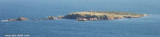
Isola delle Bisce, 21m high and barren, lies close N of Capo Ferro. This islet is not easily distinguishable from the land behind it.It is surrounded by shoals and flush rocks. A lighthouse stands on a tower 9 m high, on the S side of the island. On the N side of the rocky ...


 canal 9

 prises Tel et TV
 220/380v


 This marina is the most important of all the Smeralda coast. It is in a a wide cove accessible by a narrow channel.
")
 Ce port de plaisance est le plus important de toute la Costa Smeralda. Il a été aménagé dans une vaste anse accessible par un étroit goulet.
")
 Questa marina è il più grande porto turistico in Costa Smeralda. E 'stato costruito in una baia larga accessibile da uno stretto canale.
")