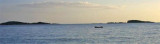
Srebreno, South Dalmatia, is located on the Zupski Zaljev N, 10 kilometres southeast of the city of Dubrovnik. It has a small port for docking small boats.
Mooring along the quay or anchor in the bay.
Open to the SW and NE winds.
2011/04/15
Update
Jojo
Srebreno, au S de la Dalmacie, est situé au N de Zupski Zaljev, à 10 km au SE de Dubrovnik. Elle a un petit port pour petits bateaux.
It is the largest and most populated island of the group Elafiten. It rises to 234 m at its N and a prominent hill rises 224 m NW of the SE end. Ruda is a small island that is 0.5 M SE of the NE extremity of the island and Misnjaka, 13 m high, lies close off the NW extremity. ...
Zupski Zaliv is entered between Rt Sustjepan and Rt Pelegrin, 2.5 miles NW. The E and SE shores of this bay are backed by mountains, but a valley through which a river flows lies within the N shore. Malastica, 628m high, stands 1 mile N of the bay. This hill has a somewhat sharp ...
Otocic Cavtatski Grebeni, a group of islets and above-water rocks, lies up to 2 miles W of Rt Sustjepan, on a line NW-SE parallel to the coast. Otocic Mrkan, the largest islet, is 65m high and appears dark from seaward. NW is the island Bobara. Between the two islands are ...
The middle bay of Boka Kotorska, is connected to Topaljski Zaliv by Kumborski Strait, a deep passage. This bay is steep and rocky on its S side, but the NE and NW shores, which are backed by mountains, are low and cultivated. Uvala Kukuljina and UvalaKrtole, separated from each ...
The island of Supetar and the shoal with a rock discovered, halfway between Supetar and extend the course to 0.7 NM NW of Rt Sv Rok. Do not get too close to the island because of the rocks that surround it. Island Supetar is 8 m high and a prominent building rises to its summit. Hr ...


 fruits et légumes en été
 Srebreno, South Dalmatia, is located on the Zupski Zaljev N, 10 kilometres southeast of the city of Dubrovnik. It has a small port for docking small boats.
 Srebreno, au S de la Dalmacie, est situé au N de Zupski Zaljev, à 10 km au SE de Dubrovnik. Elle a un petit port pour petits bateaux.