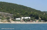
The small village of Mimice is on the shore of Bracki Kanal, 11 km from Omis and 25 km from Makarska. Her little crowded harbor offers some protection. Rocks are near the coast, 1 NM E and 0.7 NM W of the port. A wreck lies at the W Brcanceva Rt. We moored alongside the breakwater along the space available or we take a line anchored to the breakwater. Funding is from 3m to the end and middle of the dam and 1 m at its origin. Good shelter in summer.
2011/06/4
Update
Jojo
2011-06-04
Update
Jojo
Le petit village de Mimice se trouve sur la rive N du Bracki Kanal, à 11 km d'Omis et à 25 km de Makarska. Son petit port bondé offre une certaine protection.
Des rochers se trouvent près de la côte, à 1 NM à l'E et à 0,7 NM à l'W du port. Une épave se trouve à l'W devant Rt Brcanceva.
On s'amarre le long du brise-lames suivant la place disponible ou on mouille en portant une amarre au brise-lames. Les fonds sont de 3m à l'extrémité et au milieu de la digue et à 1 m à son origine.
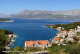
Ciovo is an island in the center of the Dalmatian archipelago. This is an area of 28.8 acres (15.3 km length, width of 3.5 km). It culminates at 218 m (Mount Rudin). O. Ciovo forms the SW side of the entrance and inner part of Kastelanski Zaliv. At East side, Ciovo is 2km from ...
Starogradski is a large deep bay, open to the NW, which houses the city and the port of Stari Grad on its SE end. There are several bays, including its N side, where it is possible to anchor. On the other side there is an anchor in front Gradisce.
Uvala Luka, at bottom, is one of the safest anchorages and sheltered more than Kanal of Brack. At the bottom of the bay, there is an abandoned farm and a footpath. Good protection from all directions.
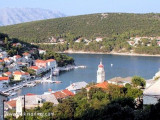
Povlja is a village NE of Brac. The best shelter is located behind the wharf where to moor at right angles if possible. You can anchor in the NW of the pier by 8 m of water.
Pucisca is the port and the largest city on the N side of Brac. It is a place known for a tradition of stone masons, and stone of Brac has been used for the construction of the White House in Washington among others. The name comes from Pucisca lat. puteus: wells as sources of ...
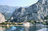
Omis is a small town and a harbour located at the mouth of the river Cetina. The city is easily identifiable by the broad gorges of the river Cetina and the fortifications on the rocks. The port is at the bottom of the bay to the east of the river mouth. Coming from the SE, ...


 sur la plage


 devant Rt Brcanceva
 The small village of Mimice is on the shore of Bracki Kanal, 11 km from Omis and 25 km from Makarska. Her little crowded harbor offers some protection.
 Le petit village de Mimice se trouve sur la rive N du Bracki Kanal, à 11 km d'Omis et à 25 km de Makarska. Son petit port bondé offre une certaine protection.