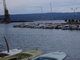
Luka Omis

Luka Omis

To precisely geolocate this site. Update if necessary.

Localisation

Characteristics

Port
Mooring
Sand Bonne tenue
Phone
Fuel à l'W de la ville
First aid
Shipyard
Shower sur la plage
Market
Restaurant
Post
Bank
South cardinal
Beach
Sand
Wreck

Description

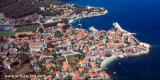
Omis is a small town and a harbour located at the mouth of the river Cetina.
The city is easily identifiable by the broad gorges of the river Cetina and the fortifications on the rocks.
The port is at the bottom of the bay to the east of the river mouth.
Coming from the SE, stay at least 0.2 NM from the coast.
Approaching from the W, attention to advanced rocky Dugi Rat (S cardinal buoy with fire), to the W of the advance.
Omitted from buoy up from the coast is very shallow as 0.3 nm.
There are several yellow buoys on the line of 5 m between Dugi Rat and the river entrance. Leave the wreck and buoy to port well in approaching the port.
We moored at the pier of the port where we anchored off the port by 5-6 m.
Can moor at the mouth of the river by 3 m or near the road bridge down by 5 m.
The port is exposed to S and W.
In the river proper protection.
2011/06/5
Update
Jojo
Luka Omis
2011-06-05
Update
Jojo
Omis est une petite ville et un port situé aux bouches de la rivière Cetina.

La ville est facilement identifiable du large par les gorges spectaculaires de la rivière Cetina et les fortifications sur les rochers.

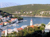
Le port est au fond de la baie, à l'E de l'embouchure de la rivière.

En venant par le SE, rester à au moins 0,2 NM de la côte.
En approchant par l'W, attention à l'avancée rocheuse de Dugi Rat (bouée cardinale S avec feu), à l'W de l'avancée.
De la bouée jusqu'à Omis, à partir de la côte c'est très peu profond jusqu'à 0,3 NM.
Il y a plusieurs bouées jaunes sur la ligne des 5 m entre Dugi Rat et l'entrée de la rivière. Laisser l'épave et la bouée bien à bâbord en approchant du port.

On s'amarre à l'appontement du port ou on mouille devant le port par 5 à 6 m.
On peut s'amarrer à l'entrée de la rivière par 3 m ou près du pont routier bas par 5 m.

Le port est exposé au S et à l'W.
Dans la rivière bonne protection.


2011/06/5
Update
Jojo
Luka Omis
2011-06-05
Update
Jojo
Luka Omis
2011-06-05
Update
Jojo
Ebook

Splitsko-dalmatinska županija (Split-Dalmatia Coun

  • 155 sites
  • 295 photos
  • publication date: 6 Jul 2023
  • .pdf file size: 97 Mb
Share your comments or photos on "Luka Omis"

Sites around Luka Omis

Flying distances - Direct line

Otok Ciovo

17nm
280°
Ciovo is an island in the center of the Dalmatian archipelago. This is an area of 28.8 acres (15.3 km length, width of 3.5 km). It culminates at 218 m (Mount Rudin).
O. Ciovo forms the SW side of the entrance and inner part of Kastelanski Zaliv.
At East side, Ciovo is 2km from ...
7 Aug 11
cdg2

Starogradski Zaljev Hvar

16nm
202°
Starogradski is a large deep bay, open to the NW, which houses the city and the port of Stari Grad on its SE end.
There are several bays, including its N side, where it is possible to anchor. On the other side there is an anchor in front Gradisce.
31 May 11
Jojo

Dugi Rat

2.3nm
271°
Small port.
17 Dec 11
florin

Otoci Pakleni

21nm
219°
Plakeni islands, or Cursed Islands, are located at the W and S of Hvar town.

The islands are rocky, covered with bushes and trees. They are usually deserted, except in summer.
They offer many choices of moorings sheltered and there is a marina Palmizana.The islands'name ...
26 May 11
Jojo

Postira (Brac)

4.8nm
216°
Postira just "Postirna" meaning "pasture." It is Postira born the Croatian poet Vladimir Nazor (1876 / 1949).
We can dock along the breakwater, dock inside is used by tour boats.
5 Jul 11
Jojo

Pucisca (Brac)

5.8nm
159°
Pucisca is the port and the largest city on the N side of Brac. It is a place known for a tradition of stone masons, and stone of Brac has been used for the construction of the White House in Washington among others.
The name comes from Pucisca lat. puteus: wells as sources of ...
5 Jul 11
Jojo