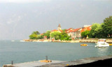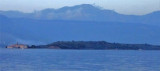


Tivaski Zaliv
4.7nm
270°
This bay is steep and rocky on its S side, but the NE and NW shores, which are backed by mountains, are low and cultivated.
Uvala Kukuljina and UvalaKrtole, separated from each ...
12 Apr 11
Jojo
| Latitude | Longitude | |
| DMS | --- | --- |
| DM | --- | --- |
| DD | --- | --- |

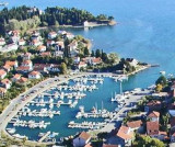
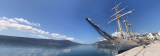
 quai principal

 en ville


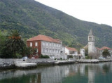
 The Old City of Kotor is a well preserved urbanization typical of the
middle Ages, built between the 12th and 14th century. Medieval
architecture and numerous monuments of cultural heritage have made Kotor
a UNESCO listed “World Natural and Historical Heritage Site".
The Old City of Kotor is a well preserved urbanization typical of the
middle Ages, built between the 12th and 14th century. Medieval
architecture and numerous monuments of cultural heritage have made Kotor
a UNESCO listed “World Natural and Historical Heritage Site".The town is backed by a rocky peak to the bottom of the Bay of Kotor.
Permanent port of entry, harbour master and customs are on the dock where you can dock.
Tel: +382 32 325573
Fax: +382 32 325572
Mail: portofkotor@cg.yu boats <150 m

 La vieille ville de Kotor, entourée d’une impressionnante muraille de
défense, est particulièrement bien préservée et classée sur la liste du patrimoine mondial de l'UNESCO. Entre 1420 et 1797, Kotor et ses environs dépendaient de Venise. Cette influence vénitienne se remarque particulièrement dans la structure et l’architecture de la ville.
La vieille ville de Kotor, entourée d’une impressionnante muraille de
défense, est particulièrement bien préservée et classée sur la liste du patrimoine mondial de l'UNESCO. Entre 1420 et 1797, Kotor et ses environs dépendaient de Venise. Cette influence vénitienne se remarque particulièrement dans la structure et l’architecture de la ville.C’est à la suite du tremblement de terre intervenu le 15 avril 1979 que l’UNESCO se décida à faire entrer la ville et le site au sein de la liste des monuments et sites classés.
La ville se trouve adossée à un pic rocheux au fond des bouches de Kotor.
Port d'entrée permanent, la capitainerie et la douane se trouvent sur le quai où l'on peut accoster.
Tel: +382 32 325573
Fax: +382 32 325572
Mail: portofkotor@cg.yu boats <150 m


Ebook | Montenegro
|