The middle bay of Boka Kotorska, is connected to Topaljski Zaliv by Kumborski Strait, a deep passage. This bay is steep and rocky on its S side, but the NE and NW shores, which are backed by mountains, are low and cultivated. Uvala Kukuljina and UvalaKrtole, separated from each ...
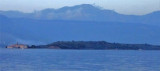
Ostrvo Stradioti, the largest of the islands lying in the SE part of the bay, is 37m high and is marked by several beacons at its W extremity. It is easily recognized against the lowlands in the background.
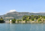
Uvala Krtole is in the area SE of Tivaski Zaljev, M Otok Island (the smallest), Stradioti (or Sveti Marko, the largest) and Prevlaka (or Ostrvo Cvijceca or "flower island", the closer the coast). You can anchor with 5 m in this protected area of the NE and N. Coming from ...
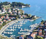
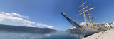
The Marina Kalimanj in Tivat is a well protected marina, a natural harbour, where the docking locations are safe. All around the Marina there are ancient Venetian palaces protected by UNESCO, old churches, restored stables. The name Tivat comes from the Celtic word "teuta", meaning town.
Plicina Jezicac, nearly awash, lies at the outer end of a spit which extends about 0.5 mile WNW from the N extremity of Ostrvo Stradioti. Vessels should not attempt to pass between this reef and the islands to the E.


 This bay is located at N Uvala Krtole.
 Cette baie se trouve au N d'Uvala Krtole.