marina et quai de la douane ou à côté hangar à carburant
marina
marina
marina
marina
Description
Port de Bar
2011-04-05
Update
Jojo
Bar marina
2011-04-05
Update
Jojo
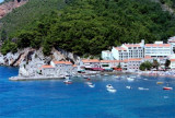
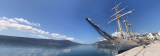
Bar is a commercial port, the country's main port and a port of entry that provides a good shelter. The approach is simple and Bar Harbour is easily identifiable by day or night. The harbor entrance is 0.8 NM to NNE of Cape Volujica. A marina is located to the east of the port and you enter through N. You can go to the customs dock, avoiding sites for tugs, ferries and pilot boats. Can moor to one of concrete pontoons of the marina. It is forbidden to anchor in the harbor. Good protection. Tel: +382 81 234353 Mail: lukabar@t-com.me
Tel/Fax marina Bar: +382 (30) 317 786 Mail: info@marinabar.org
2011/04/8
Update
dd
Bar est un port de commerce, c'est le principal port du pays et un port d'entrée qui offre un bon abri.
L'approche de Bar est simple et le port est facilement identifiable de jour comme de nuit. L'entrée du port est à 0,8 M au NNE du cap Volujica. Une marina se trouve à l'E de l'entrée du port et l'on y entre par le N.
On peut aller au quai de la douane, en évitant les emplacements réservés aux remorqueurs, Ferries et bateaux pilotes. On peut s'amarrer à l'un des pontons en béton de la marina. Il est interdit de mouiller dans le port.
Bonne protection.
Tel: +382 81 234353 Mail: lukabar@t-com.me
Tel/Fax marina Bar: +382 (30) 317 786 Mail: info@marinabar.org
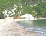
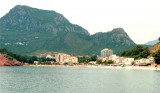
This wide bay is located 3 NM NW of Bar. Bordered by a sandy beach, is open to the S and SW. The village of Sutomore is at the bottom of the bay. The bay is distinguished by its red cliffs S of village. You can anchor in good time for the lunch, by 5 m.
The middle bay of Boka Kotorska, is connected to Topaljski Zaliv by Kumborski Strait, a deep passage. This bay is steep and rocky on its S side, but the NE and NW shores, which are backed by mountains, are low and cultivated. Uvala Kukuljina and UvalaKrtole, separated from each ...
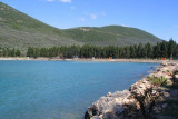
This large deep bay, at 3 M NW of Ulcinj, is open to the NW. It is surrounded by wooded hills rising to 389 m NE. Basically there is a beach lined with evergreens. The bay is a lighthouse on Rt Mendras, the tip S of the entrance. Is wetted by 4-7 m on the S side of the bay because ...
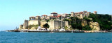
Petrovac is easily identifiable thanks to two small islands (Katic and Sveta Nedjelja with a small church) located at S. Coming from the S it is possible to pass between the islands and the mainland (9 m deep) but beware Katic Pl. We moored alongside the wharf outside because ...
Ulcinj is the southernmost city at Montenegrin coast, 8.5 NM at the northern Albanian border formed by the river Bojama (or Lum Buena). This small town is walled and fortified. It stands in the form of an amphitheater and is conspicuous from seaward. The port is located in an open ...


 canal 16, 24
 marina et quai de la douane ou à côté hangar à carburant
 marina


 marina
 marina
 marina


 Bar is a commercial port, the country's main port and a port of entry that provides a good shelter.
 Bar est un port de commerce, c'est le principal port du pays et un port d'entrée qui offre un bon abri.