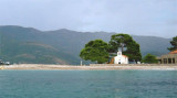
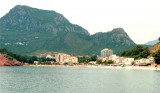
Petrovac is easily identifiable thanks to two small islands (Katic and Sveta Nedjelja with a small church) located at S. Coming from the S it is possible to pass between the islands and the mainland (9 m deep) but beware Katic Pl. We moored alongside the wharf outside because the inner basin is very shallow. Do not anchor in the bay because the bottom is lined with rocks. Protection of the N and NE only.
2011/04/5
Update
Jojo
Avoid yellow area because of rocks.
2011/06/18
Update
Petrovac est facilement identifiable grâce aux deux petites îles (Katic et Sveta nedjelja avec une petite église) qui se trouvent au S.
En arrivant du S il est possible de passer entre les îlots et le continent (9 m de fond) mais attention à Pl. Katic.
On s'amarre le long du quai à l'extérieur car le bassin intérieur est très peu profond.
Ne pas mouiller dans la baie car le fond est tapissé de roches.
The middle bay of Boka Kotorska, is connected to Topaljski Zaliv by Kumborski Strait, a deep passage. This bay is steep and rocky on its S side, but the NE and NW shores, which are backed by mountains, are low and cultivated. Uvala Kukuljina and UvalaKrtole, separated from each ...
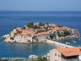
08 Mar 2010 19:01Comment: marceluisalonsomarceluisalonsoa nice place to stay Formerly a fishing village, Sveti Stefan has been converted to an exclusive resort. Although it is closed, its beauty can also be
appreciated from a distance. And beautiful it is! We anchor E of the ...
Anchoring for lunch at the W of Rt Zavala, N of Budvanska Zaljev. We approach the bay, passing S O. Sv Nikola. On the W coast of the bay, a short chain of submerged rocks from the N of the island, connecting virtually it to the mainland. We anchored in 8 m of water. Good ...
The town of Budva is easily identifiable by the island Sv Nikola, SE. The harbor is sheltered from all winds, but it can be hard to come by strong sea breezes. You can go to the dock, after asking permission to anchor in the harbor or 4 m NE of the extension of the marina by staying ...
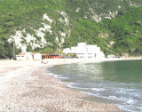
This wide bay is located 3 NM NW of Bar. Bordered by a sandy beach, is open to the S and SW. The village of Sutomore is at the bottom of the bay. The bay is distinguished by its red cliffs S of village. You can anchor in good time for the lunch, by 5 m.


 robinet sur l'esplanade
 Marché


 Petrovac is easily identifiable thanks to two small islands (Katic and Sveta Nedjelja with a small church) located at S.
 Petrovac est facilement identifiable grâce aux deux petites îles (Katic et Sveta nedjelja avec une petite église) qui se trouvent au S.