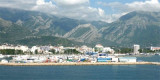
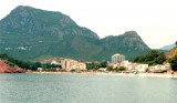
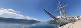
Ulcinj is the southernmost city at Montenegrin coast, 8.5 NM at the northern Albanian border formed by the river Bojama (or Lum Buena). This small town is walled and fortified. It stands in the form of an amphitheater and is conspicuous from seaward. The port is located in an open bay between the tip and the tip Barjak Kraljeve Skalice. It provides only limited shelter.
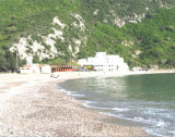
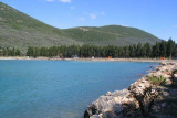
The bay is bordered by a wide range "Velika Plaza" which stretches for 13 km, the longest beach of the Adriatic.
We Can moor at the port, away from the Ferries by 4 m or anchor in the bay by 4 m. Well sheltered from N and NE, bounded by NW winds. The port is open to the S and SE winds dangerous.
2011/04/5
Update
Jojo
2011-04-05
Update
Jojo
Ulcinj est la ville la plus au S du Monténégro, à 8,5 M au NW de la frontière albanaise formée par la rivière Bojama (ou Lum Buene). Cette petite ville fortifiée, en forme d'amphitéâtre est remarquable de loin. Le port est situé dans une baie ouverte entre la pointe Barjak et la pointe Kraljeve Skalice. Il n'offre qu'un abri limité.
La baie est bordée d'une grande plage "Velika Plaza" qui s'étend sur 13 km, c'est la plus longue plage de l'Adriatique.
On peut s'amarrer au port, à l'écart des Ferries, par 4 m ou mouiller dans la baie par 4 m.
Bon abri des vents du N et NE, limité par vents de NW. Le port est ouvert au S et dangereux par vents de SE.
This large deep bay, at 3 M NW of Ulcinj, is open to the NW. It is surrounded by wooded hills rising to 389 m NE. Basically there is a beach lined with evergreens. The bay is a lighthouse on Rt Mendras, the tip S of the entrance. Is wetted by 4-7 m on the S side of the bay because ...
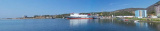
Bar is a commercial port, the country's main port and a port of entry that provides a good shelter. The approach is simple and Bar Harbour is easily identifiable by day or night. The harbor entrance is 0.8 NM to NNE of Cape Volujica. A marina is located to the east of the port ...
This wide bay is located 3 NM NW of Bar. Bordered by a sandy beach, is open to the S and SW. The village of Sutomore is at the bottom of the bay. The bay is distinguished by its red cliffs S of village. You can anchor in good time for the lunch, by 5 m.
The middle bay of Boka Kotorska, is connected to Topaljski Zaliv by Kumborski Strait, a deep passage. This bay is steep and rocky on its S side, but the NE and NW shores, which are backed by mountains, are low and cultivated. Uvala Kukuljina and UvalaKrtole, separated from each ...


 Bonne tenue


 marché


 Ulcinj is the southernmost city at Montenegrin coast, 8.5 NM at the northern Albanian border formed by the river Bojama (or Lum Buena). This small town is walled and fortified. It stands in the form of an amphitheater and is conspicuous from seaward.
 Ulcinj est la ville la plus au S du Monténégro, à 8,5 M au NW de la frontière albanaise formée par la rivière Bojama (ou Lum Buene). Cette petite ville fortifiée, en forme d'amphitéâtre est remarquable de loin.