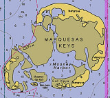

Marquesas Keys (Florida)
18nm
270°
8 Apr 12
Cham
| Latitude | Longitude | |
| DMS | --- | --- |
| DM | --- | --- |
| DD | --- | --- |

 canal 16, 13


")
Ebook | Gulf of Mexico
|
 Key West Harbor is 134 miles and 151 miles SW of Miami Harbor via the inside and coastwise routes, respectively.
Commercial fishing is one of the leading industries, but commerce is mostly in crude and refined oils.
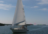
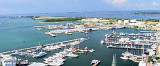
Cruise ships frequently call here, and the harbor is a safe haven for any vessel.
Easy to identify when standing along the keys are three 300-foot-high radio towers and a watertank about
0.3 mile ESE of Fort Taylor, the hotel 0.3 mile S of Key West Bight, the cupola close S of the hotel, and a
110-foot-high abandoned lighthouse 0.5 mile ENE of Fort Taylor.
Main Ship Channel is the only deep-draft approach to Key West.
The channel from the entrance to the upper turning basin is marked by lighted ranges and other aids to navigation.
Pilotage is compulsory for all foreign and U.S. vessels under register in the foreign trade drawing more than 7 feet (including tugs, barges, and tows) bound for or from Key West Harbor, Key West anchorages, and
Key West channels. Pilotage is optional for U.S. mechanically-propelled vessels in the coastwise trade that have on board a pilot properly licensed by the Federal Government.
Pilotage is available from KeyWest Bar Pilots Association, P.O. Box 848, Key West, FL 33041,
Telephone: (305) 296-5512,
Fax: (305) 296-1388.
The Pilot Station is at the NE end of Front Street, Key West. Pilot Station monitors VHF-FM channels 16 and 12 (when expecting traffic).
A minimum 24-hour notice of time of arrival is requested.
The operational guidelines in the Port of Key West are flexible due to changing conditions, different stages of current, tide, bottom shoaling, weather and the change in acceptable risk in emergency situations, Key West being a port of emergency entry as well as a cruise ship port of call and a naval station.
The main guideline is a knowledge of seamanship and the port on the part of the pilot and communication of this to the vessel's master for guidance.
The KeyWest Department of Transportation has direct supervision of mooring vessels at city properties and supervision of the anchorage mooring buoy.
The office can be contacted at 305-292-8160, 305-292-8161, or 305-294-7566 (after hours).
Anchoring in the vicinity of Key West Bight Channel Light 2, between KeyWest Bight Channel and the shoreline, is not recommended because of poor holding ground, strong currents, and obstruction of the dock approaches.
Vessels can anchor W of the city in depths of 20 to 26 feet, taking care, however, to avoid the reefs which rise abruptly in some places along the edges of the channels.
A naval explosives anchorage is about 2.5 miles SW of Key West.
A naval operational training area, aerial gunnery range, and bombing and strafing target danger zones are in the Straits of Florida and the Gulf of Mexico in the vicinity of Key West.
Caution: Craft approaching Key West, Boca Chica, and Safe Harbor from the E through Hawk Channel should be mindful that submerged rocks and reefs extend up to 0.6 mile off the keys and give little or no indication of their presence under certain conditions.
It is reported that rain squalls that move through the area during the rainy season can quickly obscure visual ranges and landmarks and make navigation of the narrow channels hazardous.
Tides: The mean range of tide is 1.3 feet at Key West.
 Situé à 134 M et 151 M au SW de Miami harbor, le port est en face de la ville de Key West, protégé du côté E par l'île et sur les autres côtés par des citernes et l'île Wisteria, les récifs et des étendues de sable.
C'est un port de pêche, de commerce et d'industrie, mais aussi de plaisance.
Le port est un havre sûr pour tous les bateaux.
Le port est facilement identifiable, quand on approche les îlots, on aperçoit trois tours radio de 90 m de haut et une citerne d'eau à environ 0,3 M à l'ESE du fort Taylor et un phare abandonné de 33 m, à 0,5 M à l'ENE de Fort Taylor.
Pour se rendre à Key West, Main Ship Channel est le chenal le plus profond (environ 10 m). Ce chenal est balisé par des feux d'alignement.
Le pilotage est obligatoire pour tout navire de commerce étranger ou américain de plus de 2 m (y compris les remorqueurs, barges et remorques) à destination de port de Key West, Key West ancrages et Key West canaux.
Le pilotage est facultatif pour les bateaux de commerce côtier américains qui ont à bord un pilotedont la licence est reconnue par le gouvernement fédéral.
Pour le pilotage contacter Key West Bar Pilots Association, P.O. Box 848, Key West, FL 33041.
Tel: (305) 296 5512
Fax: (305) 296 1388
Le bureau des pilotes se trouve à la fin de Front Street, key West. Canal: 16 et 12.
Un minimum de 24 h de délai est nécessaire pour réserver son pilote.
Les directives opérationnelles dans le port de Key West sont souples en raison de l'évolution de la marée, du courant, des bas-fonds, de la météo et en fonction des risques acceptables dans les situations d'urgence. Key West est un port d'entrée pour bateaux en situation d'urgence, mais aussi un port d'accueil de bateaux de croisière, de plaisance et une station navale.
La principale ligne directrice est une connaissance de la navigation et du port de la part du pilote qui doit communiquer avec le pilote guide.
Key West Department of Transportation doit superviser tous les mouillages du port et les mouillages sur bouées.
Tel: 305 292 8160 ou 305 292 8161 ou 305 294 7566.
Mouiller à proximité de Key West Bight Channel Light 2, entre Key West Bight Channel et le rivage n'est pas recommandé à cause du fond qui est de mauvaise tenue, du fort courant et des encombrants obstruant l'approche des quais.
Les navires peuvent mouiller à l'W de la ville par une profondeur de 6 à 8 m. Prendre garde toutefois aux récifs qui surgissent brusquement à certains endroits le long du bord du canal.
Une aire de formation marine opérationnelle de tir aérien, bombardement et mitraillage est située dans le détroit de Floride et du golfe du Mexique, à proximité de Key West.Attention, les embarcations qui approchent Key West, Boca chica, and Safe Harbor en venant de l'E vers Hawk Channel doivent prendre garde aux rochers et écueils submergés qui s'étendent à 0,6 M après les keys et qui ne sont pas indiqués.
On dit que des rafales de pluie qui se déplacent dans la zone pendant la saison des pluies peut rapidement obscurcir le champ visuel et les points de repère et rendre la navigation dans les chenaux étroits dangereuse.
Marée: L'amplitude moyenne de la marée est de 0,39 m à Key West.