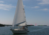
The best anchorage for medium-draft vessels less than 200 feet long is N of the city in Man of War Harbor. Depths: 14 to 26 feet. Mariners should exercise caution to avoid the visible and submerged wrecks in the harbor. It is protected against heavy seas by Frankfort Bank and Pearl Bank, on theWand Fleming Key on the E. Small craft usually anchor E of Wisteria Island, to theWof the main ship channel.
2010/03/10
Update
bjvlb
Le meilleur accostage pour les navires de moins de 60 m se situe au N de la ville dans Man of War Harbor. Profondeur: de 4,2 à 7,8 m Attention aux épaves submergées dans le port. Le port est protégé de la houle par Frankfort Bank et Pearl Bank, sur l'W, et Fleming Key sur l'E.
Les petits bateaux accostent en général à l'E de Wisteria Island, à l'W de Main Ship Channel.
2010/03/10
Update
bjvlb
Share your comments or photos on "Man of War Harbor (Key West Harbor)"
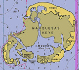
The Marquesas Keys (not to be confused with the Marquesas Islands (French Polynesia in the Pacific Ocean) form an uninhabited island group about 30 miles (50 km) west of Key West, 4 miles (6 km) in diameter, and overgrown by mangrove. They are protected as part of the Key ...
Boca Chica Key is an island in the lower Florida Keys approximately 3 miles east of the island of Key West. Its name is Spanish for "small mouth", (not "girl mouth" as many assume, since chica used as an adjective in Spanish means small).It is mainly composed of salt marshes (mangroves) ...
Stock Island is an island in the lower Florida Keys immediately east of Key West (separated from Key West by Cow Key Channel, which is only about 75 yards (70 m) wide).Immediately northwest is Key Haven (official name Raccoon Key), from which it is connected by causeway with US 1 ...
Fleming Key is an island off the northwest corner of the island of Key West, Florida in the lower Florida Keys. It is roughly 2 miles (3.2 km) long by a quarter mile wide. It is connected to the island of Key West by the Fleming Key Bridge. The island and bridge ...
Sigsbee Park, also known as Dredgers Key, is an island about a half mile north of Key West island. It is connected to the island of Key West by Sigsbee Road. The island and causeway are part of the Key West Naval Air Station. It is primarily used for Navy housing. It also includes ...
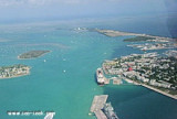
Key West Harbor is 134 miles and 151 miles SW of Miami Harbor via the inside and coastwise routes, respectively. The harbor proper is in front of the city of Key West, protected on the E side by the island and on the other sides by Tank and Wisteria Islands, reefs, and sand ...


")
 The best anchorage for medium-draft vessels less than 200 feet long is N of the city in Man of War Harbor.
 Le meilleur accostage pour les navires de moins de 60 m se situe au N de la ville dans Man of War Harbor.