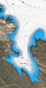
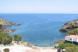
Islas La Encalladora y Maza del Oro

Islas La Encalladora y Maza del Oro

To precisely geolocate this site. Update if necessary.

Localisation

Islas La Encalladora y Maza del Oro
LatitudeLongitude
DMS------
DM------
DD------

Characteristics

Island / Atoll
Natural Park
Restricted

Description

Islas La Encalladora y Maza del Oro
Isla La Encalladora
Spain
2007-12-27
Update
Mobile
Ebook

Espagne Est - East Spain

  • 235 sites
  • 414 photos
  • publication date: 7 Jul 2023
  • .pdf file size: 180 Mb
Passing Cape Creus is not easy when it is windy, especially if it's the Tramontana blows: here, she unleashes one last time, before gradually losing its force in going south of the Spain.
This is Creus Cape that seems to pick up and stop all the violence of the Gulf of Lions which marks the end - no wonder then that in the gossip of the pontoons, Cape Creus is the consonance of "Kap Hoorn? ...

Nevertheless the passage between the island Clavaguera (Encalladora) (located NE Cape) and Cape is practicable during nice weather. Blanks of the cliff shores and there are on average 18 to 20 m of water in the channel.

To the east you will find the island of El Oro Maza is steep, except for W. Throughout this section there are volcanic more or less traces of gold ....
2012/07/9
Update
Jojo
Islas La Encalladora y Maza del Oro
isla Encalladora
2012-07-09
Update
Jojo
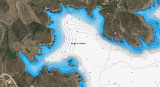
Le passage du Cap Creus n'est pas aisé lorsqu'il y a du vent, surtout si c'est la Tramontane qui souffle: ici, elle se déchaîne une dernière fois, avant de perdre progressivement sa vigueur en allant vers le sud de l'Espagne.
C'est le Cap Creus qui semble ramasser et stopper toute la violence du Golfe du Lion dont il marque la fin - pas étonnant alors que dans les potins des pontons, Cap Creus prend des consonances de "Kap Hoorn?...

Néanmoins le passage entre l'île  Clavaguera (Encalladora) (située au NE du cap) et le cap est praticable les jours de beau temps. Les flans de la falaise sont accores et il y a en moyenne 18 à 20 m d'eau dans le chenal.

A l'Est vous trouverez l'île El Maza de Oro qui est accore, sauf à l'W. Dans toute cette partie volcanique on trouve encore plus ou moins des traces d'or....
2012/07/9
Update
Jojo
Islas La Encalladora y Maza del Oro
Isla Maza del Oro
2012-07-09
Update
Jojo
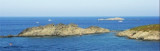
La Isla Encalladora (Illa Encalladora) es una isla de la provincia de Gerona (España). Está integrada dentro del parque natural marítimo-terrestre del Cabo de Creus, formando esta isla una reserva natural integral, por lo que toda actividad en ella está prohibida si no es con fines científicos y previa autorización.
2008/04/19
Update
Share your comments or photos on "Islas La Encalladora y Maza del Oro"

Sites around Islas La Encalladora y Maza del Oro

Flying distances - Direct line

Bahia de Rosas

9.2nm
241°
Rosas bay lies between Rio Muga and La Bateria (or Blancals) point.
8 Jul 12
Jojo

Cabo Creus

0.4nm
241°
Cape Creus is the last foothills of the Pyrenees and place the most easterly of the Iberian Peninsula.
It is a steep and rocky promontory, 672 meters, which juts out over the Mediterranean Sea, forming a small peninsula character montagneux.Sa coast is rocky, composed of slate, ...
10 Jul 12
Jojo

Cala de Culip (Cabo Creus)

0.7nm
267°
Cala Culip is a small natural harbour remarkable to see.
Good anchorage, sheltered from the NW in the pit right in front of the boats of the club-med.
The site is wild.

Leaving Cala Culip and bound east you can pass safely between the Island and Cape Creus Encalladora. ...
10 Jul 12
Jojo

Cala Guillola (Cadaquès)

1.7nm
234°
The cala Guillola is sheltered from all winds. Simply choose ... there are 3 good anchorages. We anchor by 15 to 7 m of water.
9 Jul 12
Jojo

Isla Port Lligat (Cadaquès)

2.2nm
215°
The island of Port Lligat and its neighbor Fernera island, are before the cove of Port Lligat which is only available to fishermen.
A narrow channel, about thirty feet wide, separates the island from the mainland.
9 Jul 12
Jojo