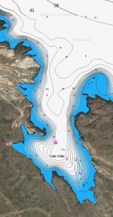
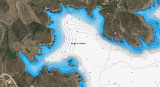
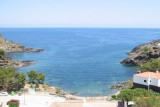
Cabo Creus

Cabo Creus

To precisely geolocate this site. Update if necessary.

Localisation

Characteristics

Lighthouse
Diving
Natural Park
Restricted

Description

Cabo Creus
2006:07:24 09:57:31
2011-02-24
Update
Cabo Creus
Le phare du Cap Creus se trouve à 87 m d'altitude et sa lumière peut être perçue jusqu'à 34 Milles.
2012-07-09
Update
Jojo
Cabo Creus
2012-07-09
Update
Jojo
Ebook

Espagne Est - East Spain

  • 235 sites
  • 414 photos
  • publication date: 7 Jul 2023
  • .pdf file size: 180 Mb
Cape Creus is the last foothills of the Pyrenees and place the most easterly of the Iberian Peninsula.
It is a steep and rocky promontory, 672 meters, which juts out over the Mediterranean Sea, forming a small peninsula character montagneux.Sa coast is rocky, composed of slate, and continually broken by small bays . Fauna and flora of the area are quite unique and host a variety of very rare species.
It is worked by waves, due mainly to the north wind, wind from north / northwest, and east winds.

In winter season winds north and NW, currents near the Cap de Creus are S and are violent.

In these places, there are rainfalls of between 500 and 800 mm per year. Winter is dominated by very strong northerly winds that hinder fishing and shipping. As a result the area around Cape recorded a very small environmental pollution and is well renowned as underwater paradise for divers.

The Natural Park of Cap de Creus has a peculiarity: it is a protected area that includes a marine area and land area. San Salvador is its highest peak.

Cape is overwhelmed by the island NE Clavaguera (Encalladora).
2012/07/10
Update
Jojo
La Cala Fredosa au pied du Cap Creus (Sud).
2012/07/9
Update
Jojo
Le Cap Creus est le dernier contrefort des Pyrénées et le lieu le plus vers l'est de la péninsule ibérienne.
C'est un promontoire abrupt et rocheux, de 672 m d'altitude, qui s'avance sur la Mer Méditerranée, formant une petite péninsule de caractère montagneux.Sa côte est rocheuse, composée d'ardoise, et continuellement cassée par des petites criques. La faune et la flore du secteur sont tout à fait uniques et hébergent une variété d'espèces très rares.

Il est travaillé par les vagues, dues principalement à la tramontane, vent de nord/nord-ouest, et aux vents d'est. 

En hiver, saison des vents de Nord et de NW, les courants aux abords du cap de Creus portent au S et sont violents.

En ces lieux, on enregistre des précipitations d'entre 500 et 800 mm par an. L'hiver est dominé par les vents du nord très forts qui gênent la pêche et le trafic maritime. Par conséquence le secteur autour du Cap enregistre une pollution environnementale très petite; il est ainsi renommé en tant que paradis sous-marin pour les plongeurs.

Le Parc Naturel de Cap de Creus a une particularité : c'est une zone protégée qui englobe une zone marine et une zone terrestre. Le San Salvador est son pic le plus élevé.

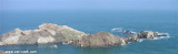
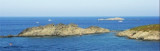
Le cap est débordé au NE par l'île Clavaguera (Encalladora).

2012/07/10
Update
Jojo
La península del cabo de Creus es uno de los parques naturales (constituido en el año 1998 ) de más superficie protegida de Cataluña, de una extensión total de 13.886 ha.
El faro de Cap de Creus emite dos destellos cada 10 segundos con un alcance de 20 millas.
2012/07/9
Update
Jojo
Share your comments or photos on "Cabo Creus"

Sites around Cabo Creus

Flying distances - Direct line

Bahia de Rosas

8.7nm
241°
Rosas bay lies between Rio Muga and La Bateria (or Blancals) point.
8 Jul 12
Jojo

Islas La Encalladora y Maza del Oro

0.4nm
69°
Passing Cape Creus is not easy when it is windy, especially if it's the Tramontana blows: here, she unleashes one last time, before gradually losing its force in going south of the Spain.
This is Creus Cape that seems to pick up and stop all the violence of the Gulf of ...
9 Jul 12
Jojo

Cala de Culip (Cabo Creus)

0.3nm
297°
Cala Culip is a small natural harbour remarkable to see.
Good anchorage, sheltered from the NW in the pit right in front of the boats of the club-med.
The site is wild.

Leaving Cala Culip and bound east you can pass safely between the Island and Cape Creus Encalladora. ...
10 Jul 12
Jojo

Cala Guillola (Cadaquès)

1.3nm
230°
The cala Guillola is sheltered from all winds. Simply choose ... there are 3 good anchorages. We anchor by 15 to 7 m of water.
9 Jul 12
Jojo

Isla Port Lligat (Cadaquès)

1.8nm
208°
The island of Port Lligat and its neighbor Fernera island, are before the cove of Port Lligat which is only available to fishermen.
A narrow channel, about thirty feet wide, separates the island from the mainland.
9 Jul 12
Jojo