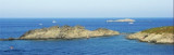
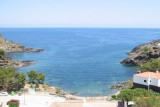
Cala Culip is a small natural harbour remarkable to see. Good anchorage, sheltered from the NW in the pit right in front of the boats of the club-med. The site is wild.
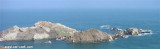
Leaving Cala Culip and bound east you can pass safely between the Island and Cape Creus Encalladora. blanks of the cliff shores and there are on average 18 to 20 m of water in the channel. For the record, on your right you will see a lighthouse and a house demolished that appear are the sets in place to shoot the film "The lighthouse at the end of the world". small houses in the background no longer exist, the latter having been destroyed on July 11 in front of us!
La tramontane a eu raison du phare du bout du monde depuis un moment déjà mais le passage (beau temps uniquement) entre Encallador et le cap et super surtout la nuit par pleine lune.
2013/05/27
Update
Cala Culip
2017-07-10
Update
Anonymous
la Cala Culip est un petit port naturel remarquable à visiter. Bon mouillage, abrité du NW dans le creux à droite en face des bâteaux du club-med. Le site est sauvage.
Sortant de Cala Culip et faisant route vers l'Est vous pouvez passer sans crainte entre l'Ile la Encalladora et le Cap Creus. les flans de la falaise sont accores et il y a en moyenne 18 à 20 m d'eau dans le chenal. Pour la petite histoire, vous verrez sur votre droite un phare et une maison qui semblent démolis ce sont des décors mis en place pour tourner le film "Le phare du bout du monde".
les petites maisons du fond n'existent plus, la dernière ayant été détruite le 11 juillet dernier devant nous !
2012/07/10
Update
Jojo
Share your comments or photos on "Cala de Culip (Cabo Creus)"
Passing Cape Creus is not easy when it is windy, especially if it's the Tramontana blows: here, she unleashes one last time, before gradually losing its force in going south of the Spain. This is Creus Cape that seems to pick up and stop all the violence of the Gulf of ...
Cape Creus is the last foothills of the Pyrenees and place the most easterly of the Iberian Peninsula. It is a steep and rocky promontory, 672 meters, which juts out over the Mediterranean Sea, forming a small peninsula character montagneux.Sa coast is rocky, composed of slate, ...
The island of Port Lligat and its neighbor Fernera island, are before the cove of Port Lligat which is only available to fishermen. A narrow channel, about thirty feet wide, separates the island from the mainland.


 Cala Culip is a small natural harbour remarkable to see.
")
")
")
 la Cala Culip est un petit port naturel remarquable à visiter.