Santa Margarita is a network of navigable channels, composed of private marinas. The Nautic Center, starboard on the Grand Canal, is a water sports center offering services and moorings.Warning: waterways are narrow. At the mouth and in the main channel, navigate close to ...
Empuriabrava is called "the largest marina in the world", an area with more channels on the water than Venice itself. Boat owners have their moorings in front of their houses. This marina was built on a swamp in 1968. Today the site covers an area of over 503 hectares, of ...
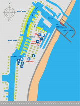
The Yacht club is N fishing harbour, with a S entrance. The width of the harbor entrance is about 70 m. and depth 9 m.Tel. 34- 972 154 412Fax 34- 972 153 768e-mail: info@portroses.com483 b. incl 110 visit. (6 to the 45 m, 65 <18 m)Depth: 6/3 m


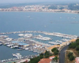
 Rosas bay lies between Rio Muga and La Bateria (or Blancals) point.
 La baie de Rosas s'étend entre le Rio Muga et la pointe de La Bateria (ou Blancals).