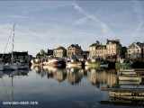
On one of the most varied coast of La Manche, Port Carentan offers "you" an execptional site. The basin, suprounded by grass and trees, blends perfectly into the town. The acces to Port Carentan, is through one of the most beautiful parts of "Parc Naturel des Marais du Cotentin". Port Carentan is open at all times, to all types of boats. Special berthing for multihulls.
Berthing : 310 berth including 50 visitor's
depth 3 M minimun
2007/11/25
Update
2007/11/25
Update
Sur une des côtes les plus variées de la Manche, Port Carentan vous offre un site exceptionnel. Le bassin entouré de verdure est parfaitement intégré dans la ville. Pour accéder à Port Carentan, vous traverserez l'une des parties les plus typiques du Parc Naturel des Marais du Cotentin. Port Carentan peut recevoir toute l'année. Le Port est ouvert à tous types de bateaux avec des emplacements réservés aux multicoques.
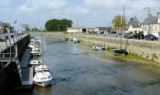
Isigny a small drying port, lies 1.5 miles inland on the Aure River. It is used by small coasters, fishing vessels, and pleasure craft. Passe d’Isigny, the entrance channel, is indicated by a lighted range and marked by buoys and beacons. The inner part of this channel leads ...
Rade de la Capelle, a roadstead lying between Banc du Cardonnet and Baie du Grand Vey, provides anchorage sheltered from S and SW winds, in a depth of 12m, mud and sand, good holding ground. Care is necessary to avoid several dangerous wrecks lying in this vicinity.
The islands are directly administered by the French government, and form a protected nature reserve with restricted access. Mooring is allowed between the 2 islands.
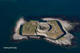
A light is shown from a square tower, 17m high, standing on Ile du Large, the NE island. Ile de Terre, lying 0.3 ...
Grandcamp-Maisy, a small harbor, lies 1.5 miles E of Pointe de Maisy and 4.5 miles W of Pointe de la Percee. It is used by fishing vessels and yachts. The approach channel is indicated by a lighted range. The entrance channel has a minimum width of 18m and dries 2m. The entrance is ...
Tatihou est une île protégée, trois hectares aux limites du fort y ont été établis en réserve ornithologique. On peut y voir des oiseaux nicheurs : goélands argentés, bruns et marins, tadornes de Belon?
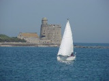
Saint-Vaast-la-Hougue is a small harbor lying 1.8 miles SW of Pointe de Saire. Ile de Tatihou, lying 1 mile E, fronts the harbor. A conspicuous tower, with a turret on one side, stands on the S extremity of the island. Fort de l’Ilet, a low fort, is situated close S of this ...


 On one of the most varied coast of La Manche, Port Carentan offers "you" an execptional site. The basin, suprounded by grass and trees, blends perfectly into the town.
 Sur une des côtes les plus variées de la Manche, Port Carentan vous offre un site exceptionnel. Le bassin entouré de verdure est parfaitement intégré dans la ville.