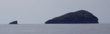
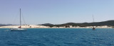
Golfo di Palmas is entered between Teulada cape to SEand Sperone cape to SW. It is bounded to W by the E coast of San Antioco island. The head of Golfo di Palmas consists of a low and sandy isthmus which connects Isola di Sant’ Antioco to the mainland.
The gulf is open to the S, the seas raised by winds from that direction are considerably decreased by the time they reach the inner roadstead anchorages.
2012/10/26
Update
Joëlle
Le Golfe de Palmas s'étend entre le Cap Teulada au SE et le cap Sperone, au SW. Il est délimité à l'W par la côte E de l'île San Antioco. Le fond du golfe de Palmas se compose d'un isthme bas et sablonneux qui connecte l'île de Sant'Antioco au continent sarde.
Le golfe est ouvert aux vents du S, mais la mer soulevée par le vent du S diminue considérablement à l'approche des points de mouillage à l'intérieur du golfe.
2012/10/26
Update
Joëlle
Il Golfo di Palmas si trova tra il capo Teulada a SE e il capo Sperone, a SW. E' delimitato all'W dalla costa E dell'isola San Antioco. Il fondo del Golfo di Palmas è composto da uno basso istmo sabbioso che collega l'isola Sant'Antioco alla terraferma di Sardegna.
Il golfo è aperto ai venti di S, ma il mare portata dal vento di S si riduce notevolmente quando si avvicina ancoraggi nel Golfo.
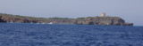
Punta Menga (or Punta Candiani) is located W Porto Pino. It is covered with low végétation and is 31 m high. The tip is known locally as Candiani. The name comes from the anti-aircraft battery-called anti-ship, of Admiral Camillo Candiani, located on Punta Menga.
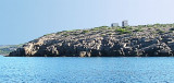
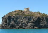
Cannai (or Canai) tower built in 1757, remained active until 1815. She had a supervisory role of information and communication to military units responsible for the defense of the island Sant Antioco.
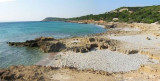
Porto Pino is bordered in its southern part by a rocky coastline with high dunes. N coast is formed instead of a low range. The tip Menga limits Porto Pino W. A lagoon, behind the sand dunes, homes several colonies of flamingos.
After Cannai tower appears Cannai Bay (Porto Cannai). It is a set of three beautiful beaches. You can anchor, in about 4 m, in the W bay, well protected from the NW winds.


")